Press Release
all 42, Currently Page 3/5
-
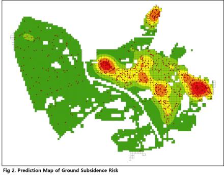 Preventing Ground Collapse through New AI-based Monitoring
-Utilizing digital underground information to predict urban ground collapse risks-
As severe urban overcrowding is trending worldwide many underground development projects are being carried out in metropolitan centers worldwide. South Korea has experienced problems such as aging underground facilities and inaccurate information management due to rapid urban development since the 1970s and 1980s. Accident prevention has become a major challenge since accidents in underground spaces have occurred due to various causes. The Korean government is undertaking projects to digitize underground facilities and ground information and establish a 3D underground space information database to prevent underground safety accidents that cause casualties and property damage. However, there hasn't been a concrete solution for the digital-information-based underground safety management, which is the primary goal of this database development. The Korea Institute of Civil Engineering and Building Technology (KICT, President Kim Byung-suk) has developed an AI-based predictive model, which is called “AI-based CRPM(Collapse Risk Prediction Model)”, that effectively provides warning for the risk of ground collapse using 3D underground space information. The newly developed AI-based CRPM applies to actual sites, capable of predicting risks using only the elements included in the existing digital underground information set up by local governments. Korea has seen its share of ground collapse accidents caused by damage to underground facilities or loss of soil under roads and buildings. For example, the rupture of a heat transport pipe that led to the fatal ground collapse accident at Baekseok Station in Ilsan and the collapse of a convenience store at Naksan Beach in Yangyang led to extreme damage. It is crucial to prepare for unexpected large-scale disaster damages such as the collapses in Guatemala City, Guatemala and Guangzhou, China.
The AI-based CRPM developed by Dr. Kang Jaemo's research team is based on an AI algorithm that predicts the risk of ground collapse by utilizing attribute information of six types of urban underground facilities (water, sewage, communication, electricity, gas, heating). This model predicts the risk of ground collapse in three stages (safe, caution, and danger). Reliability analysis conducted for areas where actual ground collapses occurred showed an accuracy of approximately 80%. The developed AI-based CRPM has a feature that visualizes the three-stage risk levels on a GIS-based map, allowing it to be used as an accident prevention decision-making safety tool when prioritized and detailed investigations in risky sections or the early replacement of underground facilities are required.
The AI-based CRPM developed by the KICT research team demonstrates high reliability and is ready for on-site usage. Additional research is underway to improve its reliability to over 90% for even more precise predictions. Dr. Kang Jaemo, the lead researcher, said, "Our newly developed model is expected to predict ground collapse risks accurately and significantly contribute to the prevention of future underground safety accidents when adopted by local governments."
###The Korea Institute of Civil Engineering and Building Technology, a government-funded research institute with 40 years of extensive research experience, is at the forefront of solving national issues that are directly related to the quality of the people’s life. This research was part of a major KICT project, "Underground Space DB Accuracy Improvement and Underground Utilities Safe Management Technology (project no. 20230116-001)", funded by the Ministry of Science and ICT. The research findings have been published in the latest issue of the international academic journal in applied science, 'IEEE Access' (IF: 3.9).
Regdate 2023/09/14
Preventing Ground Collapse through New AI-based Monitoring
Preventing Ground Collapse through New AI-based Monitoring
-Utilizing digital underground information to predict urban ground collapse risks-
As severe urban overcrowding is trending worldwide many underground development projects are being carried out in metropolitan centers worldwide. South Korea has experienced problems such as aging underground facilities and inaccurate information management due to rapid urban development since the 1970s and 1980s. Accident prevention has become a major challenge since accidents in underground spaces have occurred due to various causes. The Korean government is undertaking projects to digitize underground facilities and ground information and establish a 3D underground space information database to prevent underground safety accidents that cause casualties and property damage. However, there hasn't been a concrete solution for the digital-information-based underground safety management, which is the primary goal of this database development. The Korea Institute of Civil Engineering and Building Technology (KICT, President Kim Byung-suk) has developed an AI-based predictive model, which is called “AI-based CRPM(Collapse Risk Prediction Model)”, that effectively provides warning for the risk of ground collapse using 3D underground space information. The newly developed AI-based CRPM applies to actual sites, capable of predicting risks using only the elements included in the existing digital underground information set up by local governments. Korea has seen its share of ground collapse accidents caused by damage to underground facilities or loss of soil under roads and buildings. For example, the rupture of a heat transport pipe that led to the fatal ground collapse accident at Baekseok Station in Ilsan and the collapse of a convenience store at Naksan Beach in Yangyang led to extreme damage. It is crucial to prepare for unexpected large-scale disaster damages such as the collapses in Guatemala City, Guatemala and Guangzhou, China.
The AI-based CRPM developed by Dr. Kang Jaemo's research team is based on an AI algorithm that predicts the risk of ground collapse by utilizing attribute information of six types of urban underground facilities (water, sewage, communication, electricity, gas, heating). This model predicts the risk of ground collapse in three stages (safe, caution, and danger). Reliability analysis conducted for areas where actual ground collapses occurred showed an accuracy of approximately 80%. The developed AI-based CRPM has a feature that visualizes the three-stage risk levels on a GIS-based map, allowing it to be used as an accident prevention decision-making safety tool when prioritized and detailed investigations in risky sections or the early replacement of underground facilities are required.
The AI-based CRPM developed by the KICT research team demonstrates high reliability and is ready for on-site usage. Additional research is underway to improve its reliability to over 90% for even more precise predictions. Dr. Kang Jaemo, the lead researcher, said, "Our newly developed model is expected to predict ground collapse risks accurately and significantly contribute to the prevention of future underground safety accidents when adopted by local governments."
###The Korea Institute of Civil Engineering and Building Technology, a government-funded research institute with 40 years of extensive research experience, is at the forefront of solving national issues that are directly related to the quality of the people’s life. This research was part of a major KICT project, "Underground Space DB Accuracy Improvement and Underground Utilities Safe Management Technology (project no. 20230116-001)", funded by the Ministry of Science and ICT. The research findings have been published in the latest issue of the international academic journal in applied science, 'IEEE Access' (IF: 3.9).
Regdate 2023/09/14
-
 Understanding river alteration via shifting flow regime
- Long-term investigation shows bio-geomorphic alteration through shifting flow regime in a modified monsoonal river -
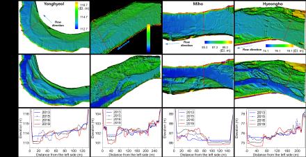
Researchers at the Korea Institute of Civil Engineering and Building Technology (KICT, President Kim Byung-suk) published their findings on the drastic short-term alterations in rivers accompanied by shifts in vegetation and geomorphology drawn from actual on-site investigation and analyses and not from model simulations.The alteration processes from a 'white river,' characterized by riverbeds with no vegetation including bare sandbars, to a densely vegetated 'green river' with grass and trees, have been observed in various rivers. Rivers are where continuous interactions between flowing water, vegetation, and morphology occur. The alteration arises from a combination of both natural and human factors, such as climate change and environmental change in the watershed. The alteration can also be triggered by short-term hydrological shifts like droughts, particularly in rivers affected by the monsoon climate, characterized by abundant precipitation in summer and prevailing dry conditions in winter. The research team led by Dr. Chanjoo Lee at KICT has conducted a research project in collaboration with the Dutch research institute Deltares to analyze the characteristics of short-term river alterations found in Naeseongcheon Stream, South Korea, and interpret their causes.Naeseongcheon Stream, which flows through the inland areas of Gyeongsangbuk-do Province, is a dynamic sandy river with well-preserved natural features, vibrant vegetation dynamics, and active sediment transport due to hydrological fluctuations. KICT has been conducting long-term monitoring of the Naeseongcheon Stream since 2012 before significant vegetation encroachment started using light detection and ranging (or LiDAR) surveys, hydrological surveys, and vegetation mapping. Dr. Chanjoo Lee’s research team used aerial photographs of the area from the 1990s to 2019, with LiDAR survey data gathered from 2013 for the project. The research findings revealed that Naeseongcheon Stream had experienced a gradual increase in vegetation encroachment on the riverbed since the 1990s, but the most significant surge occurred between 2014 and 2015. The sharp increase was attributed to a decrease in water flow and the absence of flooding due to a drought that affected the area during that period. As a result, the riverbed has undergone a rapid alteration from a typical white river to a heavily vegetated green river. From the geomorphological perspective, the sand river that once flowed wide and shallow became narrow and deep, allowing the surrounding areas once covered with water and sandbars to turn into lush floodplains overgrown with vegetation.In the joint research, KICT and Deltares identified several underlying factors contributing to the changes in Naeseongcheon Stream, including artificial factors such as water quality issues (eutrophication) that many modern rivers face, rising spring temperatures that lead to early vegetation encroachment and growth, and climate change as an over-arching driver, which causes temperature rise and fluctuations in river flow. Shorter white river phases formed by flooding and longer green river phases dominated by abundant vegetation can be observed as sand rivers in temperate climates like Naeseongcheon Stream gradually undergo sub-tropicalization caused by climate change. “Through this research, we gain insights into the interactions between hydrology, vegetation, and river morphology, which contribute to river alterations," said Dr. Chanjoo Lee at KICT, the lead researcher of the project. "We anticipate that the research findings can be utilized in formulating river management strategies, including flood control and vegetation management.”
###The Korea Institute of Civil Engineering and Building Technology, a government-funded research institute with 40 years of extensive research experience, is at the forefront of solving national issues that are directly related to the quality of the people’s lives.The research was conducted backed by the Ministry of Science and ICT. An article explaining the results of this research was published in the latest issue of River Research and Applications, a renowned international journal in the environmental sciences and water resources (IF:2.2).
Regdate 2023/08/22
Understanding river alteration via shifting flow regime
Understanding river alteration via shifting flow regime
- Long-term investigation shows bio-geomorphic alteration through shifting flow regime in a modified monsoonal river -
Researchers at the Korea Institute of Civil Engineering and Building Technology (KICT, President Kim Byung-suk) published their findings on the drastic short-term alterations in rivers accompanied by shifts in vegetation and geomorphology drawn from actual on-site investigation and analyses and not from model simulations.The alteration processes from a 'white river,' characterized by riverbeds with no vegetation including bare sandbars, to a densely vegetated 'green river' with grass and trees, have been observed in various rivers. Rivers are where continuous interactions between flowing water, vegetation, and morphology occur. The alteration arises from a combination of both natural and human factors, such as climate change and environmental change in the watershed. The alteration can also be triggered by short-term hydrological shifts like droughts, particularly in rivers affected by the monsoon climate, characterized by abundant precipitation in summer and prevailing dry conditions in winter. The research team led by Dr. Chanjoo Lee at KICT has conducted a research project in collaboration with the Dutch research institute Deltares to analyze the characteristics of short-term river alterations found in Naeseongcheon Stream, South Korea, and interpret their causes.Naeseongcheon Stream, which flows through the inland areas of Gyeongsangbuk-do Province, is a dynamic sandy river with well-preserved natural features, vibrant vegetation dynamics, and active sediment transport due to hydrological fluctuations. KICT has been conducting long-term monitoring of the Naeseongcheon Stream since 2012 before significant vegetation encroachment started using light detection and ranging (or LiDAR) surveys, hydrological surveys, and vegetation mapping. Dr. Chanjoo Lee’s research team used aerial photographs of the area from the 1990s to 2019, with LiDAR survey data gathered from 2013 for the project. The research findings revealed that Naeseongcheon Stream had experienced a gradual increase in vegetation encroachment on the riverbed since the 1990s, but the most significant surge occurred between 2014 and 2015. The sharp increase was attributed to a decrease in water flow and the absence of flooding due to a drought that affected the area during that period. As a result, the riverbed has undergone a rapid alteration from a typical white river to a heavily vegetated green river. From the geomorphological perspective, the sand river that once flowed wide and shallow became narrow and deep, allowing the surrounding areas once covered with water and sandbars to turn into lush floodplains overgrown with vegetation.In the joint research, KICT and Deltares identified several underlying factors contributing to the changes in Naeseongcheon Stream, including artificial factors such as water quality issues (eutrophication) that many modern rivers face, rising spring temperatures that lead to early vegetation encroachment and growth, and climate change as an over-arching driver, which causes temperature rise and fluctuations in river flow. Shorter white river phases formed by flooding and longer green river phases dominated by abundant vegetation can be observed as sand rivers in temperate climates like Naeseongcheon Stream gradually undergo sub-tropicalization caused by climate change. “Through this research, we gain insights into the interactions between hydrology, vegetation, and river morphology, which contribute to river alterations," said Dr. Chanjoo Lee at KICT, the lead researcher of the project. "We anticipate that the research findings can be utilized in formulating river management strategies, including flood control and vegetation management.”
###The Korea Institute of Civil Engineering and Building Technology, a government-funded research institute with 40 years of extensive research experience, is at the forefront of solving national issues that are directly related to the quality of the people’s lives.The research was conducted backed by the Ministry of Science and ICT. An article explaining the results of this research was published in the latest issue of River Research and Applications, a renowned international journal in the environmental sciences and water resources (IF:2.2).
Regdate 2023/08/22
-
 Newly Developed BIM-based Digital Design Workflow for Road Safety Improvement
- Digital design optimization of traffic accident risk roads through BIM-based design technology -
The Korea Institute of Civil Engineering and Building Technology (KICT, led by President Kim Byung-suk) developed a digital model designed to identify dangerous roads where traffic accidents frequently occur while further finding optimal measures to improve the safety of such roads, thereby minimizing the risk of traffic accidents. The Korean Ministry of Land, Infrastructure and Transport, jointly with the country's local government agencies, has been implementing a project titled the "Alignment Improvement Project for Dangerous National and Provincial Roads”to prevent traffic accidents. This project aims to identify roads with a high risk of major traffic accidents and improve structural hazards found on them, preventing future traffic accidents and enhancing their functionalities as well. Under this project, dangerous roads are selected based on a combination of various factors, including their geometry, e.g., how the roads curve and slope, the number of traffic accidents, the amount of traffic, regional characteristics, and investment expenditures. Among them, however, geometry is the most significant factor in the scoring system. Simply put, the geometric structure of roads, which determines their overall shape, is considered among the major causes of traffic accidents. The existing procedure for a feasibility study for the safety improvement of dangerous roads is composed of sequential steps, including traffic accident analysis, dangerous road identification, and improvement measure establishment. Each step is conducted according to the corresponding manual and also in a fragmented manner. Among the steps of this feasibility study, formulating and designing a route plan for a single dangerous road costs about $30,700(40 million Korean won) and takes a period of more than one and a half months. Against this backdrop, a research team led by Dr. Hyounseok Moon at KICT's BIM Research Cluster developed a digital design model to create an optimized linear road model capable of identifying dangerous roads and minimizing the risk of traffic accidents on them. The developed digital design model employs big data to ensure that dangerous roads are identified and selected in an objective manner, unlike the existing method in which the selection process is conducted in a fragmented manner. Furthermore, this model is capable of creating an optimal digital road model that effectively addresses geometric safety issues found in the selected roads and minimizes the risk of traffic accidents on them. The developed digital optimization model for dangerous roads was employed to conduct a feasibility study on a single road. Priority determination based on traffic analysis and assessments, followed by the formulation and design of alternative linear routes, all cost about $23,000(30 million Korean won) and took a period of two to three weeks at the minimum. This means that the developed digital design optimization model for dangerous roads reduces the required cost and period by 30-35% on average. This research outcome was achieved as follows. First, the Traffic Accident Analysis System (TAAS), a traffic accident big data system provided by KoROAD, was analyzed to identify and select dangerous roads, thereby determining the relationship between geometric factors and the occurrence of traffic accidents. In doing so, a total of 37,128 traffic accidents (especially fatal ones) that occurred on the country's national and provincial roads from 2012 to 2020 were analyzed. Among them, 1,138 cases (accounting for 3%) were then selected, which satisfied specific conditions, for example, accidents that occurred on curved roads or inclined roads. From the ones selected above, 77 cases were further selected in which two or more traffic accidents occurred. These 77 traffic accident cases were considered to have occurred on dangerous roads, and an in-depth examination based on topographic-map and road-view analyses was further conducted on four cases among them. The digital model developed by KICT was designed to quickly and easily provide multiple optimal alternatives to the selected road design in the form of a 3D model simply by inputting conditions and entering values for variables. In addition, it can also compare these alternatives in terms of the risk of traffic accidents and the volume of earthwork required, immediately determining whether each of these alternatives satisfies the design requirements. This process allows policymakers to determine which alternative will be the best solution to minimize the risk of traffic accidents. The distinctive advantage of the developed technology is that it integrates the entire process of decision-making, from the identification of dangerous roads to the generation of optimal alternatives using a digital model; that is, maximizing the efficiency of the process via digital transition. Dr. Hyounseok Moon said, “This technology developed by KICT can be applied not only to road alignment improvement projects but also to the rapid, digital design of new, safe roads, and it will be widely used as one of the key technologies by combining various ICT solutions, including big data and AI, thereby ushering into the era of digital transformation in the construction industry.”
###This research was funded by the "Creation of Intelligent Technology-based Alignment Improvement Model for Dangerous Roads and Development of Key Technology for Geometric Verification (2021-2022, jointly conducted by Seoyoung Engineering”project implemented by the Ministry of Land, Infrastructure and Transport (Korea Agency for Infrastructure Technology Advancement) as a research project for promoting road construction and traffic technology.
Regdate 2023/07/27
Newly Developed BIM-based Digital Design Workflow for Road Safety Improvement
Newly Developed BIM-based Digital Design Workflow for Road Safety Improvement- Digital design optimization of traffic accident risk roads through BIM-based design technology -
The Korea Institute of Civil Engineering and Building Technology (KICT, led by President Kim Byung-suk) developed a digital model designed to identify dangerous roads where traffic accidents frequently occur while further finding optimal measures to improve the safety of such roads, thereby minimizing the risk of traffic accidents. The Korean Ministry of Land, Infrastructure and Transport, jointly with the country's local government agencies, has been implementing a project titled the "Alignment Improvement Project for Dangerous National and Provincial Roads”to prevent traffic accidents. This project aims to identify roads with a high risk of major traffic accidents and improve structural hazards found on them, preventing future traffic accidents and enhancing their functionalities as well. Under this project, dangerous roads are selected based on a combination of various factors, including their geometry, e.g., how the roads curve and slope, the number of traffic accidents, the amount of traffic, regional characteristics, and investment expenditures. Among them, however, geometry is the most significant factor in the scoring system. Simply put, the geometric structure of roads, which determines their overall shape, is considered among the major causes of traffic accidents. The existing procedure for a feasibility study for the safety improvement of dangerous roads is composed of sequential steps, including traffic accident analysis, dangerous road identification, and improvement measure establishment. Each step is conducted according to the corresponding manual and also in a fragmented manner. Among the steps of this feasibility study, formulating and designing a route plan for a single dangerous road costs about $30,700(40 million Korean won) and takes a period of more than one and a half months. Against this backdrop, a research team led by Dr. Hyounseok Moon at KICT's BIM Research Cluster developed a digital design model to create an optimized linear road model capable of identifying dangerous roads and minimizing the risk of traffic accidents on them. The developed digital design model employs big data to ensure that dangerous roads are identified and selected in an objective manner, unlike the existing method in which the selection process is conducted in a fragmented manner. Furthermore, this model is capable of creating an optimal digital road model that effectively addresses geometric safety issues found in the selected roads and minimizes the risk of traffic accidents on them. The developed digital optimization model for dangerous roads was employed to conduct a feasibility study on a single road. Priority determination based on traffic analysis and assessments, followed by the formulation and design of alternative linear routes, all cost about $23,000(30 million Korean won) and took a period of two to three weeks at the minimum. This means that the developed digital design optimization model for dangerous roads reduces the required cost and period by 30-35% on average. This research outcome was achieved as follows. First, the Traffic Accident Analysis System (TAAS), a traffic accident big data system provided by KoROAD, was analyzed to identify and select dangerous roads, thereby determining the relationship between geometric factors and the occurrence of traffic accidents. In doing so, a total of 37,128 traffic accidents (especially fatal ones) that occurred on the country's national and provincial roads from 2012 to 2020 were analyzed. Among them, 1,138 cases (accounting for 3%) were then selected, which satisfied specific conditions, for example, accidents that occurred on curved roads or inclined roads. From the ones selected above, 77 cases were further selected in which two or more traffic accidents occurred. These 77 traffic accident cases were considered to have occurred on dangerous roads, and an in-depth examination based on topographic-map and road-view analyses was further conducted on four cases among them. The digital model developed by KICT was designed to quickly and easily provide multiple optimal alternatives to the selected road design in the form of a 3D model simply by inputting conditions and entering values for variables. In addition, it can also compare these alternatives in terms of the risk of traffic accidents and the volume of earthwork required, immediately determining whether each of these alternatives satisfies the design requirements. This process allows policymakers to determine which alternative will be the best solution to minimize the risk of traffic accidents. The distinctive advantage of the developed technology is that it integrates the entire process of decision-making, from the identification of dangerous roads to the generation of optimal alternatives using a digital model; that is, maximizing the efficiency of the process via digital transition. Dr. Hyounseok Moon said, “This technology developed by KICT can be applied not only to road alignment improvement projects but also to the rapid, digital design of new, safe roads, and it will be widely used as one of the key technologies by combining various ICT solutions, including big data and AI, thereby ushering into the era of digital transformation in the construction industry.”
###This research was funded by the "Creation of Intelligent Technology-based Alignment Improvement Model for Dangerous Roads and Development of Key Technology for Geometric Verification (2021-2022, jointly conducted by Seoyoung Engineering”project implemented by the Ministry of Land, Infrastructure and Transport (Korea Agency for Infrastructure Technology Advancement) as a research project for promoting road construction and traffic technology.
Regdate 2023/07/27
-
 Building Energy Consumption Diet: Using Real-time Power Usage Data Integrated with Weather Info.
Building Energy Consumption Diet:Using Real-time Power Usage Data Integrated with Weather Information - Automated estimation and management of cooling & heating energy consumption for public buildings -
In recent years, many countries have been competing to develop various platforms and systems that provide services directly to the general public using ICT solutions, especially big data. Among them, Green Button, an energy data-sharing platform launched by the Obama Administration in 2012, has drawn significant attention. Green Button is a program designed to provide consumers with online access to their electricity, gas and water consumption data, further allowing them to share such data with reliable third parties only upon their request, thereby creating new value-added services. Similar to this concept, an AMI (Advanced Metering Infrastructure), which is a smart power metering system designed to provide customers with real-time data on power consumption via two-way communication, can be used to nudges customers to reduce energy consumption spontaneously. As of late August 2022, KEPCO (Korea Electric Power Corporation) completed about 48% of the penetration target for the AMI and plans on completing its penetration project by 2024 in Korea.However, questions have been raised about whether simply providing real-time power usage data can significantly reduce energy consumption. A technology that can alleviate these concerns has recently been developed in Korea.The Korea Institute of Civil Engineering and Building Technology (KICT, President Kim Byung-suk) announced that its researchers had developed a new technology allowing the data provided by the AMI to be effectively utilized. The research team of the Department of Building Energy Research (Dr. Seung-Eon Lee and Dr. Deuk-Woo Kim) developed a technique for estimating “the daily average of heating & cooling energy use intensity” by integrating the power consumption data provided by the AMI with the real-time outdoor temperature and solar irradiance data provided by the Korea Meteorological Administration. By using the technique, it becomes possible to extract new information that can be used for the energy performance evaluation of buildings with respect to heating and cooling.The developed technique is operated based on the information content (entropy) embedded in weather and power time-series data. Three weather transitions with the largest information content (from winter to spring, from spring to summer, and from fall to winter) are first identified, and the four seasons are subdivided into with respect to each building. The daily average of heating & cooling energy use intensity is then estimated based on the number of operating days and heating & cooling energy consumption for each season. For verification, the results estimated by the algorithm were compared with detailed measured data obtained from 12 buildings for business purposes. The coefficient of determination (R2) between the estimated and measured results was 0.976, confirming the ability of the algorithm to more quickly and accurately identify high-energy-consuming buildings at the regional or city level. Meanwhile, properly managing high-energy-consuming buildings is critical to achieving carbon neutrality in the building industry. To this end, it is necessary to identify high-energy-consuming buildings through relative comparison of energy consumption among buildings within a region or city of interest. For that, It is important to properly identify high-energy-consuming buildings while considering the unique characteristics of individual buildings, including their operating schedules, to be sure, but it is not an easy task to collect such information. These challenges can be mitigated by the developed technique. For example, it is possible to come up with strategies for improving energy efficiency, especially those that best suit each building type and time window, by integrating the operation of high-energy-consuming buildings, i.e., places of business run by high-energy-consuming business operators, with such data as described above during seasonal periods, such as summer and winter. Indeed, the launch of Green Button led to a reduction of power consumption by 15 million kWh, as well as a reduction of carbon dioxide emissions by 22.9 million tons in the State of California, US. The ultimate goal of this invention is full automation. The fully automated system can implement the entire process without any human intervention, from collecting data to applying logical algorithms to store, analyze, and evaluate the collected data. The research team plans to discuss the application of the technique to the “Public Buildings Energy Information System” currently run by the Korea Authority of Land & Infrastructure Safety. Given that public buildings are required to be equipped with the AMI, the developed technology, once verified for performance and further advanced, will be used as an effective tool to identify and manage high-energy-consuming buildings in a systematic manner. Dr. Seung-Eon Lee said, “Convergence between energy and ICT solutions benefits consumers in many ways, and this technology will make it possible to identify and assess high-energy-consuming buildings in a reasonable manner.”
###The Korea Institute of Civil Engineering and Building Technology, a government-funded research institute with 40 years of extensive research experience, is at the forefront of solving national issues that are directly related to the quality of the people’s lives. Research for this paper was conducted under the KICT Research Program (project no. 20220260-001, Data-Centric Checkup Technique of Building Energy Performance), funded by the Ministry of Science and ICT. The findings were published in the Building Energy Efficiency topical section of the international journal Sustainability (IF:3.889).
Regdate 2023/07/06
Building Energy Consumption Diet: Using Real-time Power Usage Data Integrated with Weather Info.
Building Energy Consumption Diet:Using Real-time Power Usage Data Integrated with Weather Information - Automated estimation and management of cooling & heating energy consumption for public buildings -
In recent years, many countries have been competing to develop various platforms and systems that provide services directly to the general public using ICT solutions, especially big data. Among them, Green Button, an energy data-sharing platform launched by the Obama Administration in 2012, has drawn significant attention. Green Button is a program designed to provide consumers with online access to their electricity, gas and water consumption data, further allowing them to share such data with reliable third parties only upon their request, thereby creating new value-added services. Similar to this concept, an AMI (Advanced Metering Infrastructure), which is a smart power metering system designed to provide customers with real-time data on power consumption via two-way communication, can be used to nudges customers to reduce energy consumption spontaneously. As of late August 2022, KEPCO (Korea Electric Power Corporation) completed about 48% of the penetration target for the AMI and plans on completing its penetration project by 2024 in Korea.However, questions have been raised about whether simply providing real-time power usage data can significantly reduce energy consumption. A technology that can alleviate these concerns has recently been developed in Korea.The Korea Institute of Civil Engineering and Building Technology (KICT, President Kim Byung-suk) announced that its researchers had developed a new technology allowing the data provided by the AMI to be effectively utilized. The research team of the Department of Building Energy Research (Dr. Seung-Eon Lee and Dr. Deuk-Woo Kim) developed a technique for estimating “the daily average of heating & cooling energy use intensity” by integrating the power consumption data provided by the AMI with the real-time outdoor temperature and solar irradiance data provided by the Korea Meteorological Administration. By using the technique, it becomes possible to extract new information that can be used for the energy performance evaluation of buildings with respect to heating and cooling.The developed technique is operated based on the information content (entropy) embedded in weather and power time-series data. Three weather transitions with the largest information content (from winter to spring, from spring to summer, and from fall to winter) are first identified, and the four seasons are subdivided into with respect to each building. The daily average of heating & cooling energy use intensity is then estimated based on the number of operating days and heating & cooling energy consumption for each season. For verification, the results estimated by the algorithm were compared with detailed measured data obtained from 12 buildings for business purposes. The coefficient of determination (R2) between the estimated and measured results was 0.976, confirming the ability of the algorithm to more quickly and accurately identify high-energy-consuming buildings at the regional or city level. Meanwhile, properly managing high-energy-consuming buildings is critical to achieving carbon neutrality in the building industry. To this end, it is necessary to identify high-energy-consuming buildings through relative comparison of energy consumption among buildings within a region or city of interest. For that, It is important to properly identify high-energy-consuming buildings while considering the unique characteristics of individual buildings, including their operating schedules, to be sure, but it is not an easy task to collect such information. These challenges can be mitigated by the developed technique. For example, it is possible to come up with strategies for improving energy efficiency, especially those that best suit each building type and time window, by integrating the operation of high-energy-consuming buildings, i.e., places of business run by high-energy-consuming business operators, with such data as described above during seasonal periods, such as summer and winter. Indeed, the launch of Green Button led to a reduction of power consumption by 15 million kWh, as well as a reduction of carbon dioxide emissions by 22.9 million tons in the State of California, US. The ultimate goal of this invention is full automation. The fully automated system can implement the entire process without any human intervention, from collecting data to applying logical algorithms to store, analyze, and evaluate the collected data. The research team plans to discuss the application of the technique to the “Public Buildings Energy Information System” currently run by the Korea Authority of Land & Infrastructure Safety. Given that public buildings are required to be equipped with the AMI, the developed technology, once verified for performance and further advanced, will be used as an effective tool to identify and manage high-energy-consuming buildings in a systematic manner. Dr. Seung-Eon Lee said, “Convergence between energy and ICT solutions benefits consumers in many ways, and this technology will make it possible to identify and assess high-energy-consuming buildings in a reasonable manner.”
###The Korea Institute of Civil Engineering and Building Technology, a government-funded research institute with 40 years of extensive research experience, is at the forefront of solving national issues that are directly related to the quality of the people’s lives. Research for this paper was conducted under the KICT Research Program (project no. 20220260-001, Data-Centric Checkup Technique of Building Energy Performance), funded by the Ministry of Science and ICT. The findings were published in the Building Energy Efficiency topical section of the international journal Sustainability (IF:3.889).
Regdate 2023/07/06
-
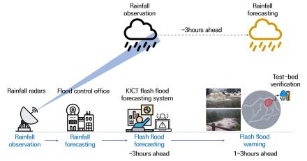 Forecasting Flash Floods an Hour in Advance
- Forecasting of localized flash floods, based on rainfall radar, to commence soon -
Korea has recently seen a surge in localized torrential rain and floods due to global warming. Frequent flash floods are hard to forecast and, when forecast, the accuracy is low. This often leads to major disasters that take hundreds of lives, as seen in Germany and China (Henan) in July 2021. Floods are one of the deadliest types of natural disasters, but climate change has made the forecasting of them even more challenging.Researchers at the Korea Institute of Civil Engineering and Building Technology (KICT, President Kim Byung-Suk) have developed a system that can forecast flash floods one hour in advance.A flash flood is caused by a rapid rise of water flowing into adjacent streams or rivers because of intense rainfall concentrated in small areas and occurs in a fairly short period of time. In low-lying urban areas such as Gangnam in Seoul and in mountainous areas, the speeds of water surge and flow are much faster than in other areas with the same amounts of rainfall. The current heavy rain alert (forecasting based on a certain level of rainfall) is a far cry from actual, perceived risk of flooding. It falls far short of efficiently communicating the risk of flash floods that abruptly hit cities, mountainous areas, or regions along small rivers.The research team at the KICT, led by Dr. Hwang Seokhwan, developed a system for these regions that forecasts abrupt flash floods based on the rainfall radar data from the Ministry of Environment with regional flood characteristics taken into account. This system will begin to provide forecasting services by the Korean government this year.The flash flood forecasting system extracts local factors that determine the depth of flooding and the extent of flood damage in different regions and conditions based on the information about the damage from previous floods and specific characteristics of regional floods. With these, the system derives its own equations of the characteristics and uses them to predict the risks of flash floods in areas that do not have any flood damage information. More specifically, it transfers the hydrological characteristics of the areas with measurements to those without measurements to provide accurate forecasting data about the risk of a flash flood to cities as well as islands and mountainous areas. This is the first system of its kind for forecasting floods.These technical features enable fast and accurate calculation of flash flood risks in any region, including cities, mountains, and islands. This, in turn, enables accurate forecasting of a flash flood coming an hour later in just a few minutes. During a four-year period of pilot operation from 2019 to 2022, the system proved its effectiveness by accurately forecasting the major flash floods in all areas of Korea about an hour in advance. Its success rate in forecasting flash floods was an impressive 90.3% for 31 heavy rainfall events during the public verification in 2019.Dr. Hwang said, "No matter how accurate a forecasting is, its forecast does not have any value as information if it does not come soon enough." He added, "This forecasting system is expected to significantly reduce the casualties and property damage caused by flash floods as their coming can be predicted at least one hour in advance.”###The Korea Institute of Civil Engineering and Building Technology, a government-funded research institute with 40 years of extensive research experience, is at the forefront of solving national issues that are directly related to the quality of the people’s life. The technology, developed by the KICT, will be transferred to the Flood Control Office of the Ministry of Environment and be applied to issuance of flood alerts first in Seoul in the 2023 rainy season.
Regdate 2023/06/28
Forecasting Flash Floods an Hour in Advance
Forecasting Flash Floods an Hour in Advance- Forecasting of localized flash floods, based on rainfall radar, to commence soon -
Korea has recently seen a surge in localized torrential rain and floods due to global warming. Frequent flash floods are hard to forecast and, when forecast, the accuracy is low. This often leads to major disasters that take hundreds of lives, as seen in Germany and China (Henan) in July 2021. Floods are one of the deadliest types of natural disasters, but climate change has made the forecasting of them even more challenging.Researchers at the Korea Institute of Civil Engineering and Building Technology (KICT, President Kim Byung-Suk) have developed a system that can forecast flash floods one hour in advance.A flash flood is caused by a rapid rise of water flowing into adjacent streams or rivers because of intense rainfall concentrated in small areas and occurs in a fairly short period of time. In low-lying urban areas such as Gangnam in Seoul and in mountainous areas, the speeds of water surge and flow are much faster than in other areas with the same amounts of rainfall. The current heavy rain alert (forecasting based on a certain level of rainfall) is a far cry from actual, perceived risk of flooding. It falls far short of efficiently communicating the risk of flash floods that abruptly hit cities, mountainous areas, or regions along small rivers.The research team at the KICT, led by Dr. Hwang Seokhwan, developed a system for these regions that forecasts abrupt flash floods based on the rainfall radar data from the Ministry of Environment with regional flood characteristics taken into account. This system will begin to provide forecasting services by the Korean government this year.The flash flood forecasting system extracts local factors that determine the depth of flooding and the extent of flood damage in different regions and conditions based on the information about the damage from previous floods and specific characteristics of regional floods. With these, the system derives its own equations of the characteristics and uses them to predict the risks of flash floods in areas that do not have any flood damage information. More specifically, it transfers the hydrological characteristics of the areas with measurements to those without measurements to provide accurate forecasting data about the risk of a flash flood to cities as well as islands and mountainous areas. This is the first system of its kind for forecasting floods.These technical features enable fast and accurate calculation of flash flood risks in any region, including cities, mountains, and islands. This, in turn, enables accurate forecasting of a flash flood coming an hour later in just a few minutes. During a four-year period of pilot operation from 2019 to 2022, the system proved its effectiveness by accurately forecasting the major flash floods in all areas of Korea about an hour in advance. Its success rate in forecasting flash floods was an impressive 90.3% for 31 heavy rainfall events during the public verification in 2019.Dr. Hwang said, "No matter how accurate a forecasting is, its forecast does not have any value as information if it does not come soon enough." He added, "This forecasting system is expected to significantly reduce the casualties and property damage caused by flash floods as their coming can be predicted at least one hour in advance.”###The Korea Institute of Civil Engineering and Building Technology, a government-funded research institute with 40 years of extensive research experience, is at the forefront of solving national issues that are directly related to the quality of the people’s life. The technology, developed by the KICT, will be transferred to the Flood Control Office of the Ministry of Environment and be applied to issuance of flood alerts first in Seoul in the 2023 rainy season.
Regdate 2023/06/28
-
 Photocatalytic Concrete for Clean Air in Underground Tunnels
 -Trial application and performance evaluation of photocatalytic concrete for reducing fine particulate matter in underground roads-
The air quality in underground road tunnels tends to be worse than in other road environments due to the poor air circulation. To address this issue, researchers at the Korea Institute of Civil Engineering and Building Technology (KICT, President Kim Byung-Suk) have developed photocatalytic concrete that can effectively remove fine particulate matter on roads.
The most effective way to improve internal air quality in road infrastructure is to pre-emptively remove fine particulate matter precursors generated by automobile exhaust gases. Therefore, the application of construction materials that make use of photocatalysts with the capability to remove harmful substances has recently been in the spotlight as a solution to fine particulate matter pollution.
A photocatalyst is a semiconducting material that can break down pollutants through a photocatalytic reaction when exposed to light. Photocatalysts react with light to produce reactive oxygen species (ROS) with strong oxidizing power, which converts the precursors of fine particulate matter (nitrogen oxide, sulfur oxide, etc.) into harmless substances through a photocatalytic reaction, leading to suppression of fine particulate matter generation.
KICT’s Green Construction by Photocatalyst Research Group (GCP Research Group) has developed a photocatalytic concrete that can reduce fine particulate matter generation through the strong oxidizing power of ROS generated when the photocatalyst reacts with light.
Despite the excellent performance of photocatalysts in removing toxic substance from the air, they have yet to be used in construction materials due to high manufacturing cost; As a result, the GCP Research Group has been developing key technologies for cost-efficient mass production of photocatalysts from wastewater sludge since 2018, with the support of the Ministry of Land, Infrastructure and Transport. Through this project, the GCP Research Group succeeded in developing a photocatalytic construction materials and application technology that achieved both technical performance and economic competitiveness..
In May 2023, the GCP Research Group completed a trial application of photocatalytic concrete on the inner walls of the Banpo Underground Road Tunnel in Seoul, Korea. This trial aimed to verify the effectiveness of the research findings in actual use. The outcomes showed an approximate 18% reduction in nitrogen oxides (NOx) concentration levels over a period of 24 hours. An artificial light source was installed on the wall of the underground road tunnel where the photocatalytic concrete was applied, allowing the photocatalytic function to work even underground where natural light does not reach. Additionally, the outcomes demonstrated that the products of photocatalytic degradation, which that converted into salts due to the calcium content in photocatalytic concrete, were effectively washed away by rain. This allows the photocatalytic function to last permanently without the need for maintenance.
The GCP research group is also conducting research to establish various photocatalytic performance evaluation certification systems. aiming to facilitate the commercialization and distribution of the technology. Currently, they are conducting a comprehensive trial in collaboration with authorities in Gyeonggi-do Province to demonstrate the effectiveness of photocatalytic construction technologies.
"Construction technology using photocatalysts can have an immediate effect on reducing fine particulate matter in the nation’s living environment” said Dr. Jong-Won, Kwark, head researcher of the research. “We plan to build a system of cooperation with local governments and public corporations to expand trial demonstrations to other sites to achieve commercialization and distribution with practical effects.”
### The Korea Institute of Civil Engineering and Building Technology, a government-funded research institute with 40 years of extensive research experience, is at the forefront of solving national issues that are directly related to the quality of the people’s life. Research for this work was supported by the Korea Agency for Infrastructure Technology Advancement (KAIA) grant funded by the Ministry of Land, Infrastructure and Transport (Grant 21SCIP-B149189-04).
Regdate 2023/06/05
Photocatalytic Concrete for Clean Air in Underground Tunnels
Photocatalytic Concrete for Clean Air in Underground Tunnels -Trial application and performance evaluation of photocatalytic concrete for reducing fine particulate matter in underground roads-
The air quality in underground road tunnels tends to be worse than in other road environments due to the poor air circulation. To address this issue, researchers at the Korea Institute of Civil Engineering and Building Technology (KICT, President Kim Byung-Suk) have developed photocatalytic concrete that can effectively remove fine particulate matter on roads.
The most effective way to improve internal air quality in road infrastructure is to pre-emptively remove fine particulate matter precursors generated by automobile exhaust gases. Therefore, the application of construction materials that make use of photocatalysts with the capability to remove harmful substances has recently been in the spotlight as a solution to fine particulate matter pollution.
A photocatalyst is a semiconducting material that can break down pollutants through a photocatalytic reaction when exposed to light. Photocatalysts react with light to produce reactive oxygen species (ROS) with strong oxidizing power, which converts the precursors of fine particulate matter (nitrogen oxide, sulfur oxide, etc.) into harmless substances through a photocatalytic reaction, leading to suppression of fine particulate matter generation.
KICT’s Green Construction by Photocatalyst Research Group (GCP Research Group) has developed a photocatalytic concrete that can reduce fine particulate matter generation through the strong oxidizing power of ROS generated when the photocatalyst reacts with light.
Despite the excellent performance of photocatalysts in removing toxic substance from the air, they have yet to be used in construction materials due to high manufacturing cost; As a result, the GCP Research Group has been developing key technologies for cost-efficient mass production of photocatalysts from wastewater sludge since 2018, with the support of the Ministry of Land, Infrastructure and Transport. Through this project, the GCP Research Group succeeded in developing a photocatalytic construction materials and application technology that achieved both technical performance and economic competitiveness..
In May 2023, the GCP Research Group completed a trial application of photocatalytic concrete on the inner walls of the Banpo Underground Road Tunnel in Seoul, Korea. This trial aimed to verify the effectiveness of the research findings in actual use. The outcomes showed an approximate 18% reduction in nitrogen oxides (NOx) concentration levels over a period of 24 hours. An artificial light source was installed on the wall of the underground road tunnel where the photocatalytic concrete was applied, allowing the photocatalytic function to work even underground where natural light does not reach. Additionally, the outcomes demonstrated that the products of photocatalytic degradation, which that converted into salts due to the calcium content in photocatalytic concrete, were effectively washed away by rain. This allows the photocatalytic function to last permanently without the need for maintenance.
The GCP research group is also conducting research to establish various photocatalytic performance evaluation certification systems. aiming to facilitate the commercialization and distribution of the technology. Currently, they are conducting a comprehensive trial in collaboration with authorities in Gyeonggi-do Province to demonstrate the effectiveness of photocatalytic construction technologies.
"Construction technology using photocatalysts can have an immediate effect on reducing fine particulate matter in the nation’s living environment” said Dr. Jong-Won, Kwark, head researcher of the research. “We plan to build a system of cooperation with local governments and public corporations to expand trial demonstrations to other sites to achieve commercialization and distribution with practical effects.”
### The Korea Institute of Civil Engineering and Building Technology, a government-funded research institute with 40 years of extensive research experience, is at the forefront of solving national issues that are directly related to the quality of the people’s life. Research for this work was supported by the Korea Agency for Infrastructure Technology Advancement (KAIA) grant funded by the Ministry of Land, Infrastructure and Transport (Grant 21SCIP-B149189-04).
Regdate 2023/06/05
-
 A green path to net zero carbon building
A Green Path to Net Zero Carbon Building -The world's first application of CXP deck material for exterior use -
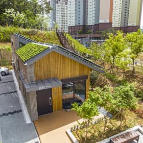
The Korea Institute of Civil Engineering and Building Technology (KICT, President Kim, Byung-Suk) made a groundbreaking achievement in the field of ecological building technology with the development of new “Net Zero Carbon Building (NZCB) system”. This innovative system, designed to minimize both operating carbon and embodied carbon, holds the key to significantly reducing carbon emissions in the construction industry.Embodied carbon, which encompasses the carbon emissions generated during the production, transportation, construction and disposal of building materials, is a critical factor in addressing carbon neutrality. In addition to the well-known "operating carbon” emitted during the building's operational phase, the reduction of "embodied carbon” from the material production stage is essential. According to Global ABC’s 2019 report, operating and embedded carbon contribute to approximately 39% of global greenhouse gas emissions.Traditionally, the construction sector has primarily focused on optimizing operational energy, such as lighting and heating, to mitigate carbon emissions. However, minimizing embodied carbon is now recognized as a fundamental requirement for achieving carbon-neutral building. In response to this challenge, the Ecological Building Research Group at KICT (Dr. Hyeon Soo Kim, Dr. Soo-Young, Moon), has successfully developed a new NZCB system capable of simultaneously reducing both operational and embodied carbon. This groundbreaking system was recently tested in Jinju City, Korea.The research team, led by Dr. Hyeon Soo Kim, incorporated thirteen major technologies into the NZCB system. Among these technologies, the most noteworthy is the adoption of the eco-friendly cement (High Sulfated Calcium Silicate Cement, HSCSC), which has the remarkable capability of reducing CO2 emissions by more than 90% while minimizing environmental impact. Ordinary Portland Cement (OPC), a commonly used concrete material, emits 1.2 kg of carbon per kg during production. In contrast, HSCSC emits only 0.07 kg of carbon per kg, resulting in a reduction of 1,130 kg of carbon emissions per ton compared to OPC.Another noteworthy advancement is the development of CXP (Cellulose X-linked Polymer), an eco-friendly thermoplastic composed solely of wood and natural resin. The research team pioneered the creation and application of CXP-based deck materials for exterior use, the first of its kind worldwide. To evaluate the efficacy of the NZCB system, the research team conducted monitoring of operational and embodied carbon reduction at the Gaho community center in Jinju City, Korea. A comparative analysis was carried out, comparing the environmental performance and embodied carbon emissions of the community center as a NZCB with that of a conventional Reinforced Concrete Building (RCB).Using the European Union's Product Environmental Footprint (PEF) guide, environmental performance was assessed across sixteen impact categories. The results indicated that the Gaho community center demonstrated superior environmental friendliness compared to steel concrete buildings. In particular, the impact on climate change, closely linked to carbon emissions, was nearly halved. Specifically, the embodied carbon impact was found to be 56.3% lower compared to the comparative RCB, resulting in a reduction of 25.7 tons of embodied carbon. Moreover, the recorded electrical energy consumption over a period of five months, starting from September 2022, suggests a potential yearly reduction of 2.2 tons of carbon emissions. This reduction is achieved by utilizing only half of the energy produced. Consequently, the Gaho community center in Jinju City emitted a total of 33.1 tons of carbon during its construction. However, the surplus electricity production is anticipated to offset 2.2 tons of embodied carbon emissions annually. This progress indicates that the Gaho community center aims to become a net zero carbon building within a span of 15 years.Dr. Hyeon Soo, Kim expressed, "The demonstration project's incorporation of thirteen innovative technologies will not only decrease carbon emissions and minimize environmental impacts in the construction industry but also make a significant contribution to the future growth of the ecological building market.”
###
The Korea Institute of Civil Engineering and Building Technology, a government-funded research institute with 40 years of extensive research experience, is at the forefront of solving national issues that are directly related to the quality of the people’s life. The research was conducted based on the funding provided by the Ministry of Land, Infrastructure and Transport (project no. RS-2018-KA146511, Development of performance criteria of ecological architecture based on Environmental Product Declaration and modularizationconstruction technology (2018-2022)). An article explaining the results of this research was published in the latest issue of CO2 emissions of concrete and timber slabs, a renowned international journal in the concrete field (IF:7.2).
Regdate 2023/06/01
A green path to net zero carbon building
A Green Path to Net Zero Carbon Building -The world's first application of CXP deck material for exterior use -
The Korea Institute of Civil Engineering and Building Technology (KICT, President Kim, Byung-Suk) made a groundbreaking achievement in the field of ecological building technology with the development of new “Net Zero Carbon Building (NZCB) system”. This innovative system, designed to minimize both operating carbon and embodied carbon, holds the key to significantly reducing carbon emissions in the construction industry.Embodied carbon, which encompasses the carbon emissions generated during the production, transportation, construction and disposal of building materials, is a critical factor in addressing carbon neutrality. In addition to the well-known "operating carbon” emitted during the building's operational phase, the reduction of "embodied carbon” from the material production stage is essential. According to Global ABC’s 2019 report, operating and embedded carbon contribute to approximately 39% of global greenhouse gas emissions.Traditionally, the construction sector has primarily focused on optimizing operational energy, such as lighting and heating, to mitigate carbon emissions. However, minimizing embodied carbon is now recognized as a fundamental requirement for achieving carbon-neutral building. In response to this challenge, the Ecological Building Research Group at KICT (Dr. Hyeon Soo Kim, Dr. Soo-Young, Moon), has successfully developed a new NZCB system capable of simultaneously reducing both operational and embodied carbon. This groundbreaking system was recently tested in Jinju City, Korea.The research team, led by Dr. Hyeon Soo Kim, incorporated thirteen major technologies into the NZCB system. Among these technologies, the most noteworthy is the adoption of the eco-friendly cement (High Sulfated Calcium Silicate Cement, HSCSC), which has the remarkable capability of reducing CO2 emissions by more than 90% while minimizing environmental impact. Ordinary Portland Cement (OPC), a commonly used concrete material, emits 1.2 kg of carbon per kg during production. In contrast, HSCSC emits only 0.07 kg of carbon per kg, resulting in a reduction of 1,130 kg of carbon emissions per ton compared to OPC.Another noteworthy advancement is the development of CXP (Cellulose X-linked Polymer), an eco-friendly thermoplastic composed solely of wood and natural resin. The research team pioneered the creation and application of CXP-based deck materials for exterior use, the first of its kind worldwide. To evaluate the efficacy of the NZCB system, the research team conducted monitoring of operational and embodied carbon reduction at the Gaho community center in Jinju City, Korea. A comparative analysis was carried out, comparing the environmental performance and embodied carbon emissions of the community center as a NZCB with that of a conventional Reinforced Concrete Building (RCB).Using the European Union's Product Environmental Footprint (PEF) guide, environmental performance was assessed across sixteen impact categories. The results indicated that the Gaho community center demonstrated superior environmental friendliness compared to steel concrete buildings. In particular, the impact on climate change, closely linked to carbon emissions, was nearly halved. Specifically, the embodied carbon impact was found to be 56.3% lower compared to the comparative RCB, resulting in a reduction of 25.7 tons of embodied carbon. Moreover, the recorded electrical energy consumption over a period of five months, starting from September 2022, suggests a potential yearly reduction of 2.2 tons of carbon emissions. This reduction is achieved by utilizing only half of the energy produced. Consequently, the Gaho community center in Jinju City emitted a total of 33.1 tons of carbon during its construction. However, the surplus electricity production is anticipated to offset 2.2 tons of embodied carbon emissions annually. This progress indicates that the Gaho community center aims to become a net zero carbon building within a span of 15 years.Dr. Hyeon Soo, Kim expressed, "The demonstration project's incorporation of thirteen innovative technologies will not only decrease carbon emissions and minimize environmental impacts in the construction industry but also make a significant contribution to the future growth of the ecological building market.”
###
The Korea Institute of Civil Engineering and Building Technology, a government-funded research institute with 40 years of extensive research experience, is at the forefront of solving national issues that are directly related to the quality of the people’s life. The research was conducted based on the funding provided by the Ministry of Land, Infrastructure and Transport (project no. RS-2018-KA146511, Development of performance criteria of ecological architecture based on Environmental Product Declaration and modularizationconstruction technology (2018-2022)). An article explaining the results of this research was published in the latest issue of CO2 emissions of concrete and timber slabs, a renowned international journal in the concrete field (IF:7.2).
Regdate 2023/06/01
-
 No More Blind Spots in Building Energy Consumption Data
 - A newly developed affordable method of estimating heating and cooling energy consumption
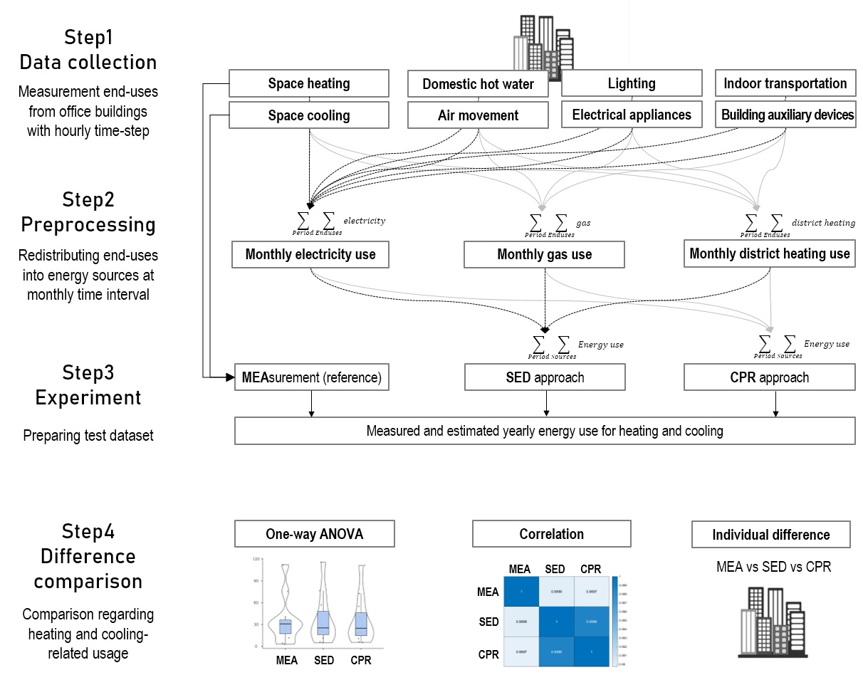
The Korea Institute of Civil Engineering and Building Technology (KICT, President Kim, Byung-Suk) developed an algorithm designed to help estimate heating and cooling consumption easily in buildings that cannot afford a building energy management system (BEMS). BEMS, which is a system designed to save energy, monitors in real time the energy consumption of buildings and provides building managers with optimized ways of energy management. The Korean government unveiled its “2050 Carbon Neutrality Roadmap for Land and Transportation” in December 2021 and set a challenging target of reducing emissions from 2018 levels by 80% by 2050. In line with the roadmap, the green remodeling of all buildings will become mandatory from 2025. However, most of the relevant regulations are focused on large, newly constructed, and energy-consuming buildings. Small-and medium-sized buildings below 1,000㎡, which account for at least 90% of existing buildings, are excluded. To reach carbon neutrality in buildings, technical support should be given to the relatively small buildings where maintenance is complex and expensive and therefore does not favour the adoption of BEMS. A more practical, realistic solution is required. Against this backdrop, a research team of the Department of Building Energy Research (Dr. Seung-Eon Lee, Dr. Deuk-Woo Kim) at KICT developed an algorithm that can easily separates and estimates the heating and cooling energy consumption from total consumption at lower cost than the existing method. It utilizes outdoor temperature data from the Korea Meteorological Administration and energy consumption data from the National Building Energy Database of the Korea Real Estate Board (REB). The algorithm uses the patterns of energy system operation, which vary across seasons; heating and cooling systems are used most in summer and winter and least in spring and autumn. Performance of the algorithm was compared and tested against extensive measurement data from 11 commercial buildings. The results showed that its error rate was within the low range between 5% and 17%. Application of the algorithm to the national energy database run by the REB will be discussed in the second half of this year. Then, a database of buildings’ heating and cooling energy consumption data will be established and make it available to all the buildings that pay energy bills. Benchmarking research on heating and cooling energy performance indicators will be conducted after the database is established. Dr. Seung-Eon Lee, who led the research, said, “The algorithm will help us quantitatively manage the progress toward carbon neutrality of buildings without a blind spot in energy consumption data.” This research accomplishment was a part of the project of the Ministry of Science and ICT, “Data-Centric Checkup Technique of Building Energy Performance (with Dr. Seung-Eon Lee as the project leader over the period from 2018 to 2022).”
###The Korea Institute of Civil Engineering and Building Technology, a government-funded research institute with 40 years of extensive research experience, is at the forefront of solving national issues that are directly related to the quality of the people’s life. Research for this paper was conducted under the KICT Research Program (project no. 20220260-001, Data-Centric Checkup Technique of Building Energy Performance) funded by the Ministry of Science and ICT. An article explaining the results of this research was published in the Special Issue of Heating and Cooling of Buildings a international journal in the Buildings (IF:3.324).
Regdate 2023/05/10
No More Blind Spots in Building Energy Consumption Data
No More Blind Spots in Building Energy Consumption Data - A newly developed affordable method of estimating heating and cooling energy consumption
The Korea Institute of Civil Engineering and Building Technology (KICT, President Kim, Byung-Suk) developed an algorithm designed to help estimate heating and cooling consumption easily in buildings that cannot afford a building energy management system (BEMS). BEMS, which is a system designed to save energy, monitors in real time the energy consumption of buildings and provides building managers with optimized ways of energy management. The Korean government unveiled its “2050 Carbon Neutrality Roadmap for Land and Transportation” in December 2021 and set a challenging target of reducing emissions from 2018 levels by 80% by 2050. In line with the roadmap, the green remodeling of all buildings will become mandatory from 2025. However, most of the relevant regulations are focused on large, newly constructed, and energy-consuming buildings. Small-and medium-sized buildings below 1,000㎡, which account for at least 90% of existing buildings, are excluded. To reach carbon neutrality in buildings, technical support should be given to the relatively small buildings where maintenance is complex and expensive and therefore does not favour the adoption of BEMS. A more practical, realistic solution is required. Against this backdrop, a research team of the Department of Building Energy Research (Dr. Seung-Eon Lee, Dr. Deuk-Woo Kim) at KICT developed an algorithm that can easily separates and estimates the heating and cooling energy consumption from total consumption at lower cost than the existing method. It utilizes outdoor temperature data from the Korea Meteorological Administration and energy consumption data from the National Building Energy Database of the Korea Real Estate Board (REB). The algorithm uses the patterns of energy system operation, which vary across seasons; heating and cooling systems are used most in summer and winter and least in spring and autumn. Performance of the algorithm was compared and tested against extensive measurement data from 11 commercial buildings. The results showed that its error rate was within the low range between 5% and 17%. Application of the algorithm to the national energy database run by the REB will be discussed in the second half of this year. Then, a database of buildings’ heating and cooling energy consumption data will be established and make it available to all the buildings that pay energy bills. Benchmarking research on heating and cooling energy performance indicators will be conducted after the database is established. Dr. Seung-Eon Lee, who led the research, said, “The algorithm will help us quantitatively manage the progress toward carbon neutrality of buildings without a blind spot in energy consumption data.” This research accomplishment was a part of the project of the Ministry of Science and ICT, “Data-Centric Checkup Technique of Building Energy Performance (with Dr. Seung-Eon Lee as the project leader over the period from 2018 to 2022).”
###The Korea Institute of Civil Engineering and Building Technology, a government-funded research institute with 40 years of extensive research experience, is at the forefront of solving national issues that are directly related to the quality of the people’s life. Research for this paper was conducted under the KICT Research Program (project no. 20220260-001, Data-Centric Checkup Technique of Building Energy Performance) funded by the Ministry of Science and ICT. An article explaining the results of this research was published in the Special Issue of Heating and Cooling of Buildings a international journal in the Buildings (IF:3.324).
Regdate 2023/05/10
-
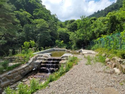 Solving drought: providing consecutive water supply from advanced sand dam
- Villagers in mountainous highlands no more suffer from water shortage during drought -
The Korea Institute of Civil Engineering and Building Technology (KICT, president Kim Byung-suk) announced the development of Korea’s first sand dam capable of supplying stable water to residents of mountainous highlands during periods of water shortage due to drought. Villagers no longer have to rely on water tank trucks during extreme drought.The coverage of waterworks for metropolitan and local water supply is nearly 97% in South Korea, but the remains are susceptible to experiencing water shortages during droughts. These regions not connected with waterworks are dependent on small-scale water supply facilities (5,920 facilities) that are sourced from valley water or groundwater. Water tank trucks often had to be mobilized to supply drinking water. In February 2016, water tank trucks and fire engines had to supply water to the nine villages in Chuncheon City, Korea because the valley water had frozen and the water sources had dried up. Residents in these regions suffer drinking water shortages in severe droughts because of their reliance on small-scale water sources. The Korean Ministry of Environment established a research group to study ways of utilizing groundwater in response to droughts. The group conducted research on new water supply for the water shortage areas, mainly located along the upstream reaches of rivers, from 2018 to 2022.Sand dams seem to be an effective solution for the valleys in mountainous areas in Korea. The technology that retains water in sand affords three advantages. Very little water is lost to evaporation; water quality improves as it passes through the sand bed; and the water does not freeze in winter. A sand dam stores water for later use in dry seasons in such arid regions as Africa where heavy rainfall occurs at rare intervals. During the flood, the dam traps turbid water and lets the sediment particles sink to the bottom for water to be stored in the sand. This primitive technology has been greatly modified and enhanced for drought solution in Korea. A research team (Dr. Lee, JeongWoo, Dr. Chang, Sun Woo, Dr. Kim, MinGyu) led by Dr. Chung, Il-Moon of the Department of Hydro Science and Engineering Research at KICT built Korea’s first bypass sand dam in Chuncheon City. The team applied the bypass type, a modified version of a sand dam, to avoid any potential unsafe issues when the dam blocks the river that runs fast through the valley.
The modified sand dam indirectly takes groundwater flow retained in the ground, gravel, or sand bed next to the flowing river. The team built the sand dam at the lower part of the small intake reservoir at the side of the main waterway and filled the space behind the dam with sand. A perforated pipeline that carries water passing through the sand bed was laid near the bottom of the sand dam. A new technique of filter pack screen in the pipeline was adopted to prevent clogging problem. The construction of the sand dam greatly increased the usual flow rate of water to 150 cubic meters per day on average and the water quality was proven to be adequate for drinking. The dam is expected to supply water for at least 10 consecutive days even during a severe drought, which is considered a long-lasting solution to a drought. Management of the bypass sand dam was transferred to Chuncheon City in 2022.Dr. Chung said, “The sand dam demonstrated that it could ensure consistent water supply even in harsh droughts driven by climate change or freezing of valley water in winter. The technology is expected to greatly improve the quality of life in the local area, and it will likely be used in other regions.”
###The Korea Institute of Civil Engineering and Building Technology (KICT) is a government sponsored research institute established to contribute to the development of Korea’s construction industry and national economic growth by developing source and practical technology in the fields of construction and national land management.This study was funded by the Korea Ministry of Environment (MOE) as a Demand Responsive Water Supply Service Program (Grant No. 146515).
Regdate 2023/04/27
Solving drought: providing consecutive water supply from advanced sand dam
Solving drought: providing consecutive water supply from advanced sand dam- Villagers in mountainous highlands no more suffer from water shortage during drought -
The Korea Institute of Civil Engineering and Building Technology (KICT, president Kim Byung-suk) announced the development of Korea’s first sand dam capable of supplying stable water to residents of mountainous highlands during periods of water shortage due to drought. Villagers no longer have to rely on water tank trucks during extreme drought.The coverage of waterworks for metropolitan and local water supply is nearly 97% in South Korea, but the remains are susceptible to experiencing water shortages during droughts. These regions not connected with waterworks are dependent on small-scale water supply facilities (5,920 facilities) that are sourced from valley water or groundwater. Water tank trucks often had to be mobilized to supply drinking water. In February 2016, water tank trucks and fire engines had to supply water to the nine villages in Chuncheon City, Korea because the valley water had frozen and the water sources had dried up. Residents in these regions suffer drinking water shortages in severe droughts because of their reliance on small-scale water sources. The Korean Ministry of Environment established a research group to study ways of utilizing groundwater in response to droughts. The group conducted research on new water supply for the water shortage areas, mainly located along the upstream reaches of rivers, from 2018 to 2022.Sand dams seem to be an effective solution for the valleys in mountainous areas in Korea. The technology that retains water in sand affords three advantages. Very little water is lost to evaporation; water quality improves as it passes through the sand bed; and the water does not freeze in winter. A sand dam stores water for later use in dry seasons in such arid regions as Africa where heavy rainfall occurs at rare intervals. During the flood, the dam traps turbid water and lets the sediment particles sink to the bottom for water to be stored in the sand. This primitive technology has been greatly modified and enhanced for drought solution in Korea. A research team (Dr. Lee, JeongWoo, Dr. Chang, Sun Woo, Dr. Kim, MinGyu) led by Dr. Chung, Il-Moon of the Department of Hydro Science and Engineering Research at KICT built Korea’s first bypass sand dam in Chuncheon City. The team applied the bypass type, a modified version of a sand dam, to avoid any potential unsafe issues when the dam blocks the river that runs fast through the valley.
The modified sand dam indirectly takes groundwater flow retained in the ground, gravel, or sand bed next to the flowing river. The team built the sand dam at the lower part of the small intake reservoir at the side of the main waterway and filled the space behind the dam with sand. A perforated pipeline that carries water passing through the sand bed was laid near the bottom of the sand dam. A new technique of filter pack screen in the pipeline was adopted to prevent clogging problem. The construction of the sand dam greatly increased the usual flow rate of water to 150 cubic meters per day on average and the water quality was proven to be adequate for drinking. The dam is expected to supply water for at least 10 consecutive days even during a severe drought, which is considered a long-lasting solution to a drought. Management of the bypass sand dam was transferred to Chuncheon City in 2022.Dr. Chung said, “The sand dam demonstrated that it could ensure consistent water supply even in harsh droughts driven by climate change or freezing of valley water in winter. The technology is expected to greatly improve the quality of life in the local area, and it will likely be used in other regions.”
###The Korea Institute of Civil Engineering and Building Technology (KICT) is a government sponsored research institute established to contribute to the development of Korea’s construction industry and national economic growth by developing source and practical technology in the fields of construction and national land management.This study was funded by the Korea Ministry of Environment (MOE) as a Demand Responsive Water Supply Service Program (Grant No. 146515).
Regdate 2023/04/27
-
 KICT Develops 3D Liquefaction Hazard Map
- Applied to Korean local governments through linkage with Seoul spatial information platform S-Map -
Korea Institute of Civil Engineering and Building Technology (KICT, president Kim Byung-suk), has successfully developed a “three-dimensional liquefaction hazard map” that visually presents ground liquefaction forecasts in the event of an earthquake.
Liquefaction is a phenomenon in which the ground surface loses its stiffness and acts like a liquid due to the repeated application of large forces generated by an earthquake. It can cause buildings or other structures to tilt or collapse, taking a heavy toll in terms of lives and property. The phenomenon, which became widely known after the 1964 Niigata and Alaska earthquakes, wreaked havoc across a broader range of ground in the 2011 Christchurch and Great East Japan earthquakes. So far, liquefaction-related damage has been frequently reported around the world.
A research team(Dr. Han, Jin-Tae, Dr. Kim, Jongkwan) at KICT’s Department of Geotechnical Engineering Research developed a 3D liquefaction hazard map that is connected to Korea’s geotechnical information portal, a database system for ground data. The map displays liquefaction risks by region in 3D upon the occurrence of an earthquake. Ground made up of soil tends to maintain its solid state up until becoming more liquid-like in the process of liquefaction, which is known as liquefaction resistance. Liquefaction resistance varies in different regions to each region’s distinct soil composition.
The research team calculated the factor of safety against liquefaction by comparing the forces applied to the ground generated by an earthquake and the soil’s resistance to liquefaction. For the calculation of regional liquefaction resistance, the team used the database of the geotechnical information portal built by KICT. It then rendered the 3D liquefaction hazard map by visualizing the safety factors by ground depth.
Typically, 2D liquefaction hazard maps are created because most structures are built on the ground surface. However, such maps are not sufficient in places like Korea that make the most of underground space due to limited land, as they are unable to accurately identify risks underground. However, the 3D map can determine the risks in underground spaces as well as those on the ground. The research team also improved the existing spatial interpolation method to apply it to the 3D map. Spatial interpolation is the process of estimating the values at unknown points by using points with known values.
KICT integrated the 3D liquefaction hazard map with S-Map OpenLab, the spatial data platform of the Seoul Metropolitan Government. S-Map is a 3D virtual reality version of Seoul that was designed to help establish policies in various areas including safety, environment and city planning and solve urban issues. The integration of the 3D liquefaction map and S-Map is expected to enable the monitoring of risks to structures not only in underground spaces but also on the ground.
Dr. Han, Jin-Tae, who led the research, said, “The 3D liquefaction hazard map in connection with the national geotechnical information portal system is expected to advance the related technology because the map includes 3D ground data for the safe management of underground spaces. The integration of the map with Seoul’s S-Map will serve as a model that can be applied to a variety of related areas.”
###The Korea Institute of Civil Engineering and Building Technology (KICT) is a government sponsored research institute established to contribute to the development of Korea’s construction industry and national economic growth by developing source and practical technology in the fields of construction and national land management.The funding for the research was provided by the Ministry of Science and ICT. An article explaining the improved 3D interpolation and its result was published in the renowned international journal, Applied Sciences, in November 2022. (IF:2.838)
Regdate 2023/04/19
KICT Develops 3D Liquefaction Hazard Map
KICT Develops 3D Liquefaction Hazard Map- Applied to Korean local governments through linkage with Seoul spatial information platform S-Map -
Korea Institute of Civil Engineering and Building Technology (KICT, president Kim Byung-suk), has successfully developed a “three-dimensional liquefaction hazard map” that visually presents ground liquefaction forecasts in the event of an earthquake.
Liquefaction is a phenomenon in which the ground surface loses its stiffness and acts like a liquid due to the repeated application of large forces generated by an earthquake. It can cause buildings or other structures to tilt or collapse, taking a heavy toll in terms of lives and property. The phenomenon, which became widely known after the 1964 Niigata and Alaska earthquakes, wreaked havoc across a broader range of ground in the 2011 Christchurch and Great East Japan earthquakes. So far, liquefaction-related damage has been frequently reported around the world.
A research team(Dr. Han, Jin-Tae, Dr. Kim, Jongkwan) at KICT’s Department of Geotechnical Engineering Research developed a 3D liquefaction hazard map that is connected to Korea’s geotechnical information portal, a database system for ground data. The map displays liquefaction risks by region in 3D upon the occurrence of an earthquake. Ground made up of soil tends to maintain its solid state up until becoming more liquid-like in the process of liquefaction, which is known as liquefaction resistance. Liquefaction resistance varies in different regions to each region’s distinct soil composition.
The research team calculated the factor of safety against liquefaction by comparing the forces applied to the ground generated by an earthquake and the soil’s resistance to liquefaction. For the calculation of regional liquefaction resistance, the team used the database of the geotechnical information portal built by KICT. It then rendered the 3D liquefaction hazard map by visualizing the safety factors by ground depth.
Typically, 2D liquefaction hazard maps are created because most structures are built on the ground surface. However, such maps are not sufficient in places like Korea that make the most of underground space due to limited land, as they are unable to accurately identify risks underground. However, the 3D map can determine the risks in underground spaces as well as those on the ground. The research team also improved the existing spatial interpolation method to apply it to the 3D map. Spatial interpolation is the process of estimating the values at unknown points by using points with known values.
KICT integrated the 3D liquefaction hazard map with S-Map OpenLab, the spatial data platform of the Seoul Metropolitan Government. S-Map is a 3D virtual reality version of Seoul that was designed to help establish policies in various areas including safety, environment and city planning and solve urban issues. The integration of the 3D liquefaction map and S-Map is expected to enable the monitoring of risks to structures not only in underground spaces but also on the ground.
Dr. Han, Jin-Tae, who led the research, said, “The 3D liquefaction hazard map in connection with the national geotechnical information portal system is expected to advance the related technology because the map includes 3D ground data for the safe management of underground spaces. The integration of the map with Seoul’s S-Map will serve as a model that can be applied to a variety of related areas.”
###The Korea Institute of Civil Engineering and Building Technology (KICT) is a government sponsored research institute established to contribute to the development of Korea’s construction industry and national economic growth by developing source and practical technology in the fields of construction and national land management.The funding for the research was provided by the Ministry of Science and ICT. An article explaining the improved 3D interpolation and its result was published in the renowned international journal, Applied Sciences, in November 2022. (IF:2.838)
Regdate 2023/04/19