본문 바로가기
오늘하루 보지않기
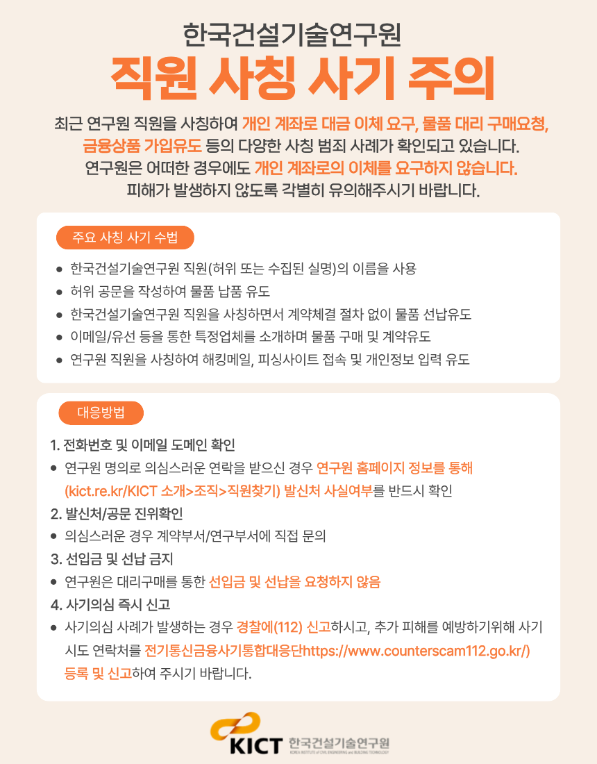
닫기
KICT 한국건설기술연구원
About KICT
Welcome Message
History
Organization
KICT CI
Related Organization
Research Division
Department of Highway & Transportation Research
Department of Structural Engineering Research
Department of Geotechnical Engineering Research
Department of Building and Urban Research
Department of Hydro Science and Engineering Research
Department of Environmental Research
Department of Future & Smart Construction Research
Department of Fire Safety Research
Department of Building Energy Research
Department of Construction Test & Certification
Department of Construction Industry Promotion
Department of Construction Policy Research
Korea Construction Standards Center
Research Information
Research Reports
Press Release
Research Facilities
Research videos
Industrial Support
Smart Construction Support Center
Smart Construction Technology Plaza
Smart Construction Alliance
SME Support
Technology Transfer
Accreditation Certification and Testing
Standard of Construction Estimate
International Cooperation
International Activities
International Memorandum of Understanding (MOU)
UST-KICT School
News & Notice
News & Notice
Global KICT
Brochure
PR Film
Newsletter
Gender Equality Plan(GEP)
직원찾기
페이스북
블로그
KOR
전체메뉴
검색
닫기
About KICT
Research Division
Research Information
Industrial Support
International
Cooperation
News & Notice
About KICT
Welcome Message
History
Organization
KICT CI
Related Organization
Research Division
Department of Highway & Transportation Research
Introduction
Staff
Papers
Department of Structural Engineering Research
Introduction
Staff
Papers
Department of Geotechnical Engineering Research
Introduction
Staff
Papers
Department of Building and Urban Research
Introduction
Staff
Papers
Department of Hydro Science and Engineering Research
Introduction
Staff
Papers
Department of Environmental Research
Introduction
Staff
Papers
Department of Future & Smart Construction Research
Introduction
Staff
Papers
Department of Fire Safety Research
Introduction
Staff
Papers
Department of Building Energy Research
Introduction
Staff
Papers
Department of Construction Test & Certification
Introduction
Staff
Papers
Department of Construction Industry Promotion
Introduction
Staff
Papers
Department of Construction Policy Research
Introduction
Staff
Papers
Korea Construction Standards Center
Introduction
Staff
Papers
Research Information
Research Reports
Press Release
Research Facilities
Ilsan HeadQuarters (Main Research Facilities)
Department of Fire Safety Research (Hwaseong)
River Experiment Center (Andong)
SOC Demonstration Research Center (Yeoncheon)
Research videos
Industrial Support
Smart Construction Support Center
Intro
Smart construction startup idea contest
Office and support space for resident companies and support for residents
Open Incubation Program
Smart Construction Innovation Startup Program
Smart Construction Technology Plaza
Intro
Registration Procedure
Review Items
Utilization Strategies
Smart Construction Alliance
Intro
SME Support
SME Support
Technology Exchange Meeting
Technology Transfer
Accreditation Certification and Testing
Standard of Construction Estimate
International Cooperation
International Activities
International Memorandum of Understanding (MOU)
UST-KICT School
News & Notice
News & Notice
Global KICT
Brochure
PR Film
Newsletter
Gender Equality Plan(GEP)
KOR
전체메뉴 닫기
Research Division
Department of Highway & Transportation Research
Introduction
Staff
Papers
Department of Structural Engineering Research
Introduction
Staff
Papers
Department of Geotechnical Engineering Research
Introduction
Staff
Papers
Department of Building and Urban Research
Introduction
Staff
Papers
Department of Hydro Science and Engineering Research
Introduction
Staff
Papers
Department of Environmental Research
Introduction
Staff
Papers
Department of Future & Smart Construction Research
Introduction
Staff
Papers
Department of Fire Safety Research
Introduction
Staff
Papers
Department of Building Energy Research
Introduction
Staff
Papers
Department of Construction Test & Certification
Introduction
Staff
Papers
Department of Construction Industry Promotion
Introduction
Staff
Papers
Department of Construction Policy Research
Introduction
Staff
Papers
Korea Construction Standards Center
Introduction
Staff
Papers
Research Achievements
Home
Research Division
Department of Land, Water and Environment Research
Research Achievements
공유하기
페이스북
트위터
카카오스토리
링크공유
프린트
검색
ALL
Subject
Content
Search
TOTAL
4
Current page
1
/
1
Development of Fast Prediction Technology for Urban Flood Forecasting
Researcher:Kim Hyung-jun, Senior Researcher, Department of Hydro Science and Engineering Research, KICT Sim Sang-bo, Postdoctoral Researcher, Department of Hydro Science and Engineering Research, KICT Prologue In recent years, climate change has accelerated the temporal concentration and spatial intensification of rainfall, leading to unprecedented flooding events that cause significant damage. During 2020, South Korea experienced prolonged monsoon rains that triggered flood damage across the country, with floods in some regions that exceeded design flood levels, resulting in substantial loss of life and property. 2022 saw localized torrential rainfall in southern Seoul that exceeded the capacity of urban drainage systems, causing widespread inundation throughout the city and resulting in casualties, particularly in the Gwanak-gu area, where many residents live in underground spaces. Such rainfall events exceeding expectations are anticipated to continue increasing. Particularly in urban areas with high ratios of impervious surfaces, the risk of flood damage from localized concentrated rainfall is rising, and this risk is expected to increase further in the future. As a countermeasure, the Ministry of Environment, based on recent cases of large-scale flood damage, is designating additional flood warning points along rivers to expand its flood forecasting coverage, and has enacted new legislation to establish an institutional foundation for implementing flood forecasting in urban areas. The Korea Institute of Civil Engineering and Building Technology (KICT) is developing urban flood forecasting models to support the Ministry of Environment's implementation of urban flood forecasting. Development of Real-Time Urban Flood Prediction Model 1. Dual Drainage Model for Urban Flood Prediction To analyze the urban inundation caused by localized torrential rainfall, it is necessary to use both a 2D model for surface runoff behavior and a 1D model for the flow within complex underground stormwater networks. The traditional method of urban inundation analysis involved first performing 1D stormwater network flow analysis, then calculating the flow discharged from the network, and applying this to a 2D model to assess the extent of surface flooding. However, this approach does not account for the possibility of flow re-entering the stormwater network from the surface, which can lead to overestimating the extent of inundation. Recent advancements have led to the development of a model that dynamically integrates stormwater network flow and surface water flow analysis, allowing for simulations in which excess stormwater flows into the network and causes flooding, and then flows back into the network, helping to resolve the flooding. The Korea Institute of Civil Engineering and Building Technology (KICT) developed the HCSURF (Hyper Connected Solution for Urban Flood) model, which allows for a simultaneous analysis of both surface water flow and stormwater network flow. The stormwater network flow analysis uses the source code of the United States Environmental Protection Agency (EPA)'s SWMM (Storm Water Management Model) version 5.2, while the surface water flow analysis uses self-developed code that discretizes the 2D shallow water equation using the Finite Volume Method (FVM). The SWMM model was written in C, while the surface water model was developed in Fortran. These were integrated into a single project in Visual Studio to allow for information exchange, and compiled into one executable file. The HC-SURF model is designed to analyze urban flooding by sharing the results of stormwater network flow and surface water flow simulations. The calculation of inflows into the stormwater network uses the results from the lumped rainfall-runoff simulation of the SWMM model, which is then sequentially linked to the surface water flow simulation. Alternatively, a distributed rainfall model can be used to perform the surface water simulation, and the inflow to the stormwater network is calculated. After comparing the surface water results, methods for calculating surplus flow and re-entry flow are reflected in the model. 2. Effective Representation of Building Shapes in Urban Areas To perform flood prediction based on rainfall runoff and surface water behavior in urban areas, it is crucial to account for the impact of various structures such as buildings and roads, which significantly affect the flow behavior. Unlike rivers, urban areas introduce additional complexity. Methods for incorporating the effects of buildings into urban flood analysis include: (a) Excluding Building Areas from the Grid: This method excludes building areas from the calculation domain; (b) Reflecting Building Proportions in the Grid: This method calculates the proportion of the grid occupied by buildings, and incorporates this into the governing equations to define the effective area; (c) Applying Modified Roughness Coefficients in Building Areas: This method involves applying higher roughness coefficients to the grids where buildings are present to control flow speed and direction. To develop an efficient numerical analysis model for urban flood forecasting, a study was conducted to examine the differences in results based on various methods of incorporating buildings into the model. The model was applied to an area near Sindaebang Station along the Dorimcheon River, which experienced a large-scale urban flood in 2022, and the results were compared, as shown in Figure 2. Figure 2 (a) shows the results of simulating the inundation range by excluding building areas from the numerical grid. While road shapes are reflected with high accuracy, areas that were not accurately captured during grid generation are excluded from the numerical simulation. This leads to the issue of excluding areas where actual inundation could occur, thus omitting flood-prone areas from the simulation. The results of simulated urban flooding that incorporates the proportion taken up by buildings in the numerical grid are shown in Figure 2 (b). The simulation results demonstrate that regardless of the shape of the grid representing the computational domain, urban flooding is reasonably simulated through roads, and the phenomenon of inundation occurring through roads is captured accurately. In areas with many buildings, the depth of inundation is not calculated, but the simulation can reasonably model urban flooding in grids where there is ample space for stormwater flow. The results of simulating urban flood inundation using modified roughness coefficients are shown in Figure 2 (c). The roughness coefficients were increased in areas with buildings to significantly raise the resistance to stormwater flow, but stormwater still flowed through areas with buildings. As a result, it was observed that, of the three simulation conditions, the urban flood inundation area was the largest under this condition. 3. Achieving Real-Time Forecasting Capability through the Application of Parallel Processing Techniques For urban flood forecasting, it is essential to minimize the simulation execution time in order to improve operational efficiency. The HC-SURF model has been developed to enable real-time urban flood forecasting by enhancing computational efficiency through the application of parallel processing techniques. Table 1 shows the computational time required by applying parallel processing techniques under each condition. When generating the numerical grid that incorporates building shapes, even though parallel processing techniques were applied, the computational time interval is determined by very small calculation grids. As a result, despite the reduction in time, longer computation times are required compared to other methods. In numerical simulations that incorporate the effects of buildings using uniform calculation grids, it was observed that not only is the time reduction ratio higher, but the computational time is also significantly shorter. Advancing Operationalization Through Pilot Testing Korea’s Ministry of Environment enacted the "Act on Flood Damage Prevention in Urban River Basins" after the large-scale urban flood that occurred in the Dorimcheon River basin in 2022, which established an institutional foundation for expanding the flood forecasting areas. Following this, a technology was developed to provide scenario-based urban flood maps for the Dorimcheon River to relevant agencies. However, there are still significant technical limitations when it comes to providing accurate urban flood information by reflecting real-time hydrological data. From its early development stages, the HC-SURF model was designed to support urban flood forecasting for the Ministry of Environment (ME), and this achieved basic performance through three years of research and development from 2022 to 2024. Starting in 2025, pilot testing will be conducted on the operational server of the Ministry of Environment (ME) Han River Flood Control Office (HRFCO) as part of the "Dam-River Digital Twin" project. In March, a real-time linkage system with the Ministry of Environment (ME) hydrological survey database will be established to enhance the model for collaborative support. During the remaining two years of the research and development period, the HC-SURF model will be further advanced to reflect the feedback of the Ministry of Environment (ME), which is the end user, and it is expected that the framework will be established to implement urban flood forecasting as a unique technology in Korea.
Department of Hydro Science and Engineering Research
Date
2025-06-23
Hit
702
AI for Flood Damage Prevention: Standing Strong Against Natural Disasters
AI for Flood Damage Prevention: Standing Strong Against Natural Disasters ▲ Senior Research Fellow Yoon Kwang-seok, Department of Hydro Science and Engineering Research (AI Flood Forecasting Research Team), KICT Last summer, the Korean Peninsula was hit hard by severe torrential rains. The monsoon front, which began on June 25, persisted until July 26. As the water level of the Seomjin River Dam neared its flood control limit of 194 meters, the dam began releasing water at a rate of up to 300 tons per second. This severe flooding led to significant loss of life and property damage. This flood, and other floods of 2000, 2022, and 2023 have underscored the growing threat of natural disasters driven by climate change. AI-based Flood Forecasting System Enabling Rapid Decision-Making The Department of Hydro Science and Engineering Research at the Korea Institute of Civil Engineering and Building Technology (KICT) identified urbanization and the high population density in developed cities as the primary causes of flooding, attributing it to a reduction in areas for rainfall infiltration. The department also predicted that the flooding issue is likely to worsen in the future. To address this, an "AI-based Flood Forecasting System" was proposed as a new solution to thoroughly prepare for the extreme floods that can occur at any time. ‘If flood forecasting were conducted solely by human resources, predictions and warnings would rely on manual analysis, leading to slower decision-making and delayed crisis responses. Starting this year, the Ministry of Environment and the Flood Control Office have decided to adopt the KICT's AI-based flood prediction model to enable more efficient forecasting and warning systems. This marks the world's first implementation of an AI-driven flood prediction model. The AI-based Flood Forecasting System consists of four stages: observation and investigation, transmission and prediction, prediction, and delivery. It automatically analyzes national flood forecasting points at 10-minute intervals and autonomously learns from big data on weather and hydrological conditions in the Han River basin. Flood forecasters verify AI-based prediction results, make a judgment on the situation, and issue flood warnings. Enhanced Accuracy, Speed, and Stability in Flood Prediction The AI-driven Long Short-Term Memory (LSTM) model applied to the system automatically predicts river water levels by learning statistical correlations from observational data, such as rainfall, water levels, and dam discharge volumes. This is a physical model that combines hydrological and hydraulic models, calculating river water levels using flow rates determined through the storage function method. Warnings are issued at points where water levels are predicted to exceed the warning threshold. The prediction scope will soon be significantly expanded. Until 2023, predictions were limited to 75 flood warning points focused on major rivers, leaving tributaries and streams more vulnerable. Starting this year, the number of flood warning points will be increased to 223, covering tributaries and smaller streams. Currently, the AI-based flood forecasting model is used in four flood control offices, with plans for gradual expansion. Forecasters can quickly predict disasters, allowing for countermeasures to be taken promptly by using the system’s dam-river digital twin technology to simulate water level changes and pinpoint areas at risk of flooding. Notably, the upstream points of rivers added as flood information provision points from this year have faster runoff speeds, making prediction difficult with conventional physics-based models alone. The AI-based flood prediction model assists in predicting and decision-making for such points. As this is the first application of an AI-based flood prediction model, the research team is continuing its research and development to achieve accuracy, speed, and stability. Senior research fellow Yoon Kwang-seok, the principal researcher, expects the AI-based flood prediction system to spread not only domestically but also globally. "As this is the first time an AI-based flood prediction model is being applied in practice, the Department of Hydro Science and Engineering Research is focusing on research to advance the technology and improve its accuracy. In particular, we expect to increase the efficiency of flood prediction by linking with conventional physics-based models and establishing an improved decision-making system. Our goal is for the AI-based flood prediction system we developed to become the world's best system." "Our goal is for the AI-based flood prediction system we developed to become the world's foremost system." KICT's Technology Expanding Globally The research team’s focus extends beyond flood-related issues. Last year’s torrential rains caused severe damage and casualties in areas like Gangnam Station and Sillim-dong in Seoul. To respond, the team is analyzing past damage caused by urban inundation and actively conducting research on monitoring and predicting urban inundation damage, with plans to continue this work through 2025. The goal is to develop flood monitoring equipment capable of measuring inundation depths in urban areas. Furthermore, the team plans to create a model that predicts inundation based on the monitoring results. These developments will be tested in countries such as the Philippines, Indonesia, and Laos to verify their adaptability. The researchers are committed to their work, believing that these advancements will pave the way for domestic technologies to reach international markets Since its establishment, the KICT's Department of Hydro Science and Engineering Research has worked consistently to address national water-related issues, such as floods, droughts, climate change, and coastal disasters, while preserving the value of the national territory. The department believes that the AI-based Flood Forecasting System will improve citizens' quality of life and lead to more effective water management. Driven by a sincere desire for a better world, the team’s research will continue to bring about meaningful changes.
Department of Hydro Science and Engineering Research
Date
2024-09-26
Hit
3244
Inundation and Flood Risk Assessment Using Rainfall Radar Technology
Inundation and Flood Risk Assessment Using Rainfall Radar Technology ▲ Senior Researcher Kang Na-rae, Department of Hydro Science and Engineering Research, KICT Prologue Recently, heavy rainfall events have become more frequent. In urban areas, heavy rains are characterized by their sudden and localized nature, resulting in a rise in human casualties and property damage. Urban areas have seen a surge in flood damage due to extreme weather events, such as localized torrential rainfalls and typhoons. Various media outlets have pointed to climate change as the cause, and have warned of the potential for more severe damage in the future. Additionally, there is growing concern as the scale of flooding in rivers and streams in the middle and upper reaches, as well as in small rivers, is gradually increasing. Furthermore, flood magnitudes are progressively increasing in the upper reaches and small streams of rivers, beyond the major rivers where flood forecasts are being carried out, leading to heightened concerns. In South Korea, flood forecasting is carried out to reduce flood damage and enable early responses based on meteorological and river conditions. Currently, these forecasts focus primarily on Korea's major rivers, where the significance of flooding is high, and observational data is collected. As such, there is a need to establish a comprehensive nationwide flood forecasting system that covers areas for which monitoring or sufficient measurement data are lacking. These areas include small and medium-sized rivers and other bodies of water, for which flood forecast information cannot currently be provided. This is essential to address the existing information gaps and deliver precise flood forecast information. The water levels of small and medium-sized rivers (and other bodies of water) are prone to experience abrupt changes within a short timeframe. This is because these rivers have the characteristic of experiencing rapid increases in water levels due to the brief time it takes for precipitation from the upstream areas to accumulate in the downstream of the rivers. It is thus crucial to focus on early forecasting of water levels, starting from the initial stages of rainfall before rapid increases occur, and to promptly gather on-site information to facilitate swift evacuations. Furthermore, in urban areas, floods triggered by localized torrential rainfalls occur suddenly and frequently in terms of both time and space, leading to increased risk to human lives and property damage. Ultimately, successful flood management in small and medium-sized rivers and urban areas hinges on how quickly observations can be conducted, and the level of detail of such observations. For this reason, research into the utilization of rainfall radar technology for rainfall and flood prediction and monitoring is actively underway. Risk Prediction Based on Rainfall Radar Rainfall radar can monitor rainfall events in real time over a wide area, and can detect rainfall fields passing through ungauged watersheds, which existing ground rain gauge observation networks cannot provide. Rainfall radar makes it possible to identify areas in which heavy rain is falling by imaging the distribution and movement of rainfall. Although it is possible to roughly identify areas where it is raining with rainfall radar, it doesn't necessarily mean that the information is consistent with whether a disaster has occurred in those areas. Most of the research conducted to date has focused primarily on the amount of rainfall, which is the dynamic factor, at the watershed scale, to assess flood risk. However, to accurately predict flood disasters, it is necessary not only to figure out the amount of rainfall but also to understand in what direction the rain that has fallen changes or escalates the situation due to the surrounding conditions, such as land conditions, land use, slope (static factors), etc. (Figure 1). The Japan Meteorological Agency has introduced a "risk index" system based on rainfall radar to provide comprehensive risk information nationwide that covers all areas, which is highly correlated with disaster occurrences, instead of relying solely on conventional rainfall-centered flood risk prediction. This system doesn't focus only on the amount of rainfall, but also pays attention to how rain that has fallen changes the situation due to potential environmental factors related to disaster occurrence, such as land conditions. It models processes like rainfall infiltration into the ground and river runoff. Through this approach, it quantifies the risk levels for each type of disaster and provides a "risk index" that allows the visual tracking of changes. As a result, the system has significantly improved the precision of forecasts of floods caused by heavy rain, and increased the relevance compared to conventional rainfall-based predictions The purpose of this text is to provide a brief introduction to an index that can precisely predict the risks of flood and inundation in urban and small to medium-sized river watersheds using grid-based observed and forecasted rainfall data generated from the rainfall radar observation network currently under development in Korea. Inundation Risk Index The Inundation Risk Index is an indicator used to assess the increase in flood risk due to heavy rainfall in a short timeframe. It indexes the increase in flooding risk by calculating how much rainfall has been accumulated and retained on the surface of the earth, taking into account the ground cover, geology, and topographic slope. The entire country is divided into a grid with a resolution of 1 km, and two types of tank models are used for each area to quantify the level of risk, considering surface cover conditions, geology, and terrain slope (Figure 2). The Inundation Risk Index primarily targets disasters in the form of inland water flooding in urban areas. However, it can be applied across the entire country, and offers a reasonable degree of precision in practical way because it doesn't require detailed input information about drainage facilities. Flood Risk Index The Flood Risk Index is an indicator used to assess the extent to which flood risk at downstream locations increases due to rainfall in the upstream region of a river. It quantifies this increase in flood risk by calculating the amount of rainfall that enters arbitrary rivers and points within local rivers using a grid with a resolution of 1 km. As depicted in Figure 3, this calculation takes into account the processes through which rainfall in the upstream area either infiltrates the surface or flows underground and eventually contributes to the river's runoff (runoff process). It also considers the subsequent flow of water downstream (run-of-river process). These calculations are based on nationwide river flow patterns, river basins, geography (topography/geology), and land use information. The Flood Risk Index allows for the establishment of a response relationship regarding the occurrence of flood events based on past flood disaster cases spanning several years. It can also provide forecasts for several hours ahead using prediction data, and can be applied to all rivers nationwide, including those where water levels and flow rates are not monitored. Utilization of Inundation and Flood Risk Indices The two indices introduced earlier are highly correlated with disaster response. However, they represent relative risks, and it is not possible to directly assess the likelihood of disaster occurrence using these index values alone. The assessment of the likelihood of disaster occurrence needs to be compared to established "criteria" based on past disaster records. This comparison ultimately influences the criteria when setting them based on past disasters. Therefore, it is believed that using the index values in conjunction with the judgment results based on criteria such as alerts, rather than relying solely on the index values themselves, can provide valuable information. The flood and inundation prediction technology based on rainfall radar introduced herein thus far has allowed for a more precise delineation of flood-prone areas and an expansion of flood information coverage to small river basins and urban areas. Providing flood information for ungauged watersheds is expected to contribute to the safety of local residents.
Department of Hydro Science and Engineering Research
Date
2023-10-11
Hit
1088
Development of Technology to Assess Water Shortage Risk and Secure Water for Small-Medium Rivers in Response to Drought
Development of Technology to Assess Water Shortage Risk and Secure Water for Small-Medium Rivers in Response to Drought ▲ Research Fellow Kim Chul-gyum, KICT Department of Hydro Science and Engineering Research Prologue Drought in Korea takes place every five to year years, statistically, and recently its occurrence and damage have become more frequent due to climate change. Aggravation of water shortage in the future, which is predicted according to climate change and increase in water consumption, will adversely affect water quality and aquatic ecosystems as well as water supply problems. In particular, the watersheds of small-medium rivers have a low ability to respond to water shortages from the drought and face repeated deterioration of the water quality and ecological environment due to water shortages. Furthermore, it is difficult for them to secure water supply through dams or reservoirs and control the flow of the rivers. Accordingly, measures for continuous water management, considering stable water security and water quality, are required for them. For effective drought response, accurate analysis and assessment of available water resources, along with rainfall prediction, and efficient water supply that can reduce the risk of water shortage based on this are required. As one of the alternatives for securing water, the reuse of sewage re-treated water is attracting attention, but the actual recycling rate is less than 20% due to concerns about the quality of reused water and aesthetic rejection. Accordingly, in order to increase the utilization rate of reused water, it is necessary to further strengthen the treatment level for water quality, while securing a safe level of water quality for various new hazardous substances that are not yet subject to regulation. In addition, in the case of small-medium rivers, eutrophication or algae is more likely to occur due to nutrients in the effluent because the amount of water discharged from the sewage treatment plant accounts for a large proportion of the river flow during drought. Therefore, it is necessary to highly upgrade the water quality treatment level for the water discharged from sewage treatment plants in order not only to secure the water quality safety of reused water but also to protect river water quality during drought. In order to solve the problems in terms of quantity and water quality that can occur in the watersheds of small-medium rivers during drought, in this study the Korea Institute of Civil Engineering and Building Technology (KICT) developed detailed technologies in three major areas, as shown in Figure 1. In the field of prediction/forecasting, we developed a technology for predicting the weather, amount of evapotranspiration, volume of runoff, etc. In the field of analysis/assessment, we developed a precision spatiotemporal hydrological analysis technology that reflects the complex water use system and physical characteristics of the watersheds of small-medium rivers; this assesses water resources availability and risk of water shortage. To secure water, we developed an advanced treatment technology for water reuse in sewage treatment plants and economical treatment technology that are superior to previous treatment processes. We also developed a technology that can dramatically reduce sludge and eutrophication-inducing substances generated in the sewage treatment process. Long-term Prediction Technology for Weather and Hydrologic Volume From a meteorological point of view, long-term prediction on a time scale ranging from one month to several months is essential information for securing and managing stable water resources and securing agricultural productivity in response to meteorological disasters, such as drought, flood, heat waves, and cold waves. Long-term prediction is mainly made by statistical models and climate models. However, it has not yet secured a sufficient level of predictability, and it is an area where attention and research have been continuously focused on in recent years. The Korea Meteorological Administration also provides forecast data for one to three months on precipitation and temperature using the results of the global climate model, which is a dynamical model. However, due to the geographical characteristics of the Korean Peninsula, sudden heavy rains or typhoons and abnormal climatic conditions have become more frequent than in the past. That is why it is not easy to accurately predict the weather. In this study, we developed a statistical model that can predict the monthly precipitation and temperature for the next one to twelve months in the Han River Sphere. We configured the prediction mode by flexibly selecting the optimal predictive parameters according to the prediction month based on the teleconnection between prediction target meteorological parameters (precipitation, temperature) and global climate patterns, making it possible to reflect meteorological and climate variability according to future climate change, etc. The forecasted monthly weather information is converted into the daily data for each major point by using the statistical downscaling technique, and the converted daily data are linked with the hydrological model. In this way, the forecasting results for hydrological parameters, such as the amount of evapotranspiration or volume of runoff, for the next 12 months also can be derived in the same way as the weather forecast period. Predicted weather and hydrologic volume information are provided through a web-based system as shown in Figure 2. Currently, monthly forecast information is being provided for the monthly precipitation, average temperature, and reference amount of evapotranspiration in the Han River Sphere, as well as the volume of runoff in the Chungju Dam watershed and the Gyeongancheon watershed. In addition, the forecast results ranging from December to the latest forecast results are being provided. Moreover, the forecast results ranging from those for January to December 1991, which were predicted based on December 1990, to the latest forecast results are provided. Precision Hydrologic Analysis and Assessment Technology for Small-Medium Rivers Watersheds Compared to the wide-area water supply regions around large rivers, water supply stability in small-medium river watersheds is relatively vulnerable during drought. Therefore, reliable prediction of the volume of runoff or available water resources is required in order to prepare comprehensive measures, such as the efficient operation of water supply facilities, assessment of water supply risk, and optimal use of available water resources. To this end, in this study we developed a water shortage risk assessment and water resources capacity assessment technology that reflects the detailed water use system (groundwater intake/drainage, sewage/wastewater discharge, etc.) and hydrological environment characteristics in watersheds during drought (Figure 3). By utilizing the developed technology, we have identified the impact of underground water intake on the accuracy of the prediction of the volume of runoff of the river watersheds for the first time in Korea. In addition, we laid the foundation for practical use to support the policies of the Ministry of Environment and local governments for the water management during drought by securing more than 70% predictive accuracy for the developed technology for each sphere of the medium-sized rivers, including Han River, Nakdong River, Geumgang, Yeongsan River, and Seomjin River. Furthermore, we developed a dynamic water resources assessment tool (DWAT), a program to assess the hydrological volume for small-medium rivers, and released it on the World Meteorological Organization (WMO) website in 2019. In June 2019, the WMO Hydrological Assembly decided that the DWAT would support the pilot project of "Global Hydrological Status and Forecasting System (HydroSOS)." In 2021, the DWAT was applied to sites in four Member States (Colombia, Argentina, the United Kingdom, and river watersheds in Bhutan). The research team continues to provide technical support related to the application and education of the DWAT through the WMO Technical Advisory Project (Figure 4). Technology for Advanced Treatment of Recycled Water Based on Advanced Oxidation Reuse of water refers to recycling the sewage and wastewater, heavy water, or stormwater that have been retreated through an appropriate water treatment technology, as water that meets the purpose of use. Reuse of water, in addition to reducing the amount of water source used, also offers benefits such as a cutdown of discharge of pollutant loads to public waters. Consequently, the need for the reuse of water is growing in terms of improving water scarcity and creating a healthy water environment. Meanwhile, it was found that new and trace pollutants/contaminants which are of concern as being hazardous to the human body or ecosystem, such as chemicals and pathogenic microorganisms, may remain in the reuse water. Accordingly, a technology for producing recycled water that can ensure the safety of reused water is required. In this study, we developed a UV-based advanced oxidation treatment process that can effectively treat residual trace organic pollutants by utilizing the TOC item newly added to the effluent water quality standards from 2020 as an index. We also secured the technology for recycling re-treated sewage water. By reducing the TOC concentration to 2.3-4.4mg/L in the secondary treated water of sewage, we have developed a process that can re-treat the sewage water, which has gone through secondary treatment, up to the level of Ib to III grade (the level that can be used as water for residential water) on the river living environment of the TOC standards. Furthermore, we secured a preemptive response technology for the treatment of unregulated new pollutants as well in order to secure the safety of recycled water, which is not currently regulated. For this, the ozone treatment process developed using a vortex-type microbubble generator was applied to 23 pharmaceuticals, including antibiotics, which are highly likely to be regulated in the future. As a result, it was confirmed, as shown in Figure 5, that pharmaceuticals can be reduced by more than 80%, and perfluorooctanesulfonic acid (PFOS), a representative material of perfluorinated compounds, can be cut down by 43%. Technology for Reuse of Sewage-treated Water with Low Energy In order to promote the use of recycled water, it is necessary to secure the safety of water quality and to develop an economical water supply plan. Korea reuses about 1 billion m3, which is 14.7% of the total sewage water treatment volume, and it is mainly used for washing water in the treatment plant, water for other uses, and water used to maintain the level of river water (74% of off-site water) (Ministry of Environment, 2015). This is because sewage-treated water effluent can be utilized directly without further treatment. In Korea, the ozone-based advanced oxidation process and membrane-based reverse osmosis (RO) process are mainly used for treatment processes for use as industrial water and agricultural water. In the case of the RO process, where membrane technology is widely used, 44% of the cost of operation and management is shown to be the energy cost for maintaining a high pressure of 12-19 bar or higher. On the other hand, the capacitive deionization (CDI) process used for seawater desalination is a technology that adsorbs ionic substances in the water onto an electric double layer, generated through electricity applied to a porous electrode composed of a dual-module, and treats them. It is known that its ion removal rate is lower than that of the RO process but the energy consumption is comparably lower. In this study, we developed a low-pressure membrane (UF)-CDI process linking an ultrafiltration membrane and CDI to derive an optimal process that can treat water meeting the target water quality level and save energy. It was compared with the target TOC concentration of 5 mg/L and confirmed that it was possible to treat up to a level of 3.62 mg/L. And in terms of energy, it was analyzed that the maintenance cost could be reduced by about 30% or more compared to that of the conventional RO process (Figure 6). Hence, it will increase the treatment efficiency of recycled water along with the ozone/ultraviolet advanced oxidation treatment process and secure sufficient water quality safety, thereby contributing to reducing the rejection of recycled water and increasing its utilization rate. Technology for Removal of Phosphorus in Water without Generation of Sludge and Recovery The nutrients contained in the sewage treatment water, including phosphates, cause eutrophication in rivers and dams, resulting in deterioration of water quality. Conventionally, the removal of phosphate contained in water has been centered on chemical treatment methods, such as rapid stirring - slow stirring - precipitation using ferric salts or aluminum. This method has a problem in that the cost of treating sludge is high due to the excessive generation of chemical sludge. Accordingly, several researchers are trying to remove phosphorus without generation of sludge by using iron components, such as iron ore, slack, and zero-valent iron, as an adsorbent for phosphate removal, but the removal efficiency is not high and the reaction time is excessively long (more than four hours). In this study, we developed the world's first sludge-free phosphate-removing and adsorbing new material to solve this problem and derived an optimal method to produce fertilizer using the removed phosphate (Figure 7). To assess the performance of the developed adsorption material, the adsorption/desorption process was repeated about 65 times. As a result, the component in the treated water was not detected at all, or it was found to be less than 0.03 mg/L, which is about 1/10 of the current water quality standard. In addition, in terms of maintenance, the net construction cost is similar to that of the conventional process (PAC+DAF)1) based on the treatment capacity of 1,000 m3/day, but the chemical agent consumption cost is found to be 1/30. It was analyzed that the economic feasibility was also excellent as 240 kg of phosphate fertilizer per month could be produced as a by-product. Technology for Crystallization of MAP to Recover Phosphorus and Nitrogen from Side Streams of Sewage Treatment Plants The average amount of water discharged from public sewage treatment plants in Korea is about 19 million m3 per day as of 2015. For watersheds of small-medium rivers like Gyeongancheon Stream, this represents a good amount of water resources, accounting for more than 70% of the quantity of flow during the low-water season. However, nutrient substances such as phosphorus and nitrogen remain in the effluent, which is highly likely to cause eutrophication and algae growth in rivers and lakes. Meanwhile, the side streams (or reject water) containing high concentrations of phosphorus and nitrogen from the sewage treatment plant are returned to the grit chamber and this rapidly increases the load of phosphorus and nitrogen in the subsequent biological treatment process, thereby ultimately lowering the water quality of the effluent. In this study, we developed a new process for crystallization of MAP (Magnesium Ammonium Phosphate) that can dramatically remove and recover nutrients, such as phosphorus and nitrogen in side streams, generated from sewage treatment facilities. In addition, the recovered MAP crystals can be used as a controlled release fertilizer (Figure 8). Design and optimal operating parameters were derived through the operation of a demonstration plant for the developed MAP crystallization process, and the basis for practical use was established through operation and maintenance manuals. The new MAP crystallization process secured more than 90% efficiency in removing phosphorus (PO4-P) in side streams by using sewage sludge incineration ash and recovering high-concentration effluent. And it raised the efficiency of removing nitrogen (NH4-N), which was on average 20% in the conventional MAP crystallization process, to more than 80%. Furthermore, it minimized the cost by using a single MgO chemical agent in the treatment process, and sufficient economic feasibility was secured for practical use by recovering MAP crystals that can be used as fertilizers. The developed new process will dramatically cut down the amount of phosphorus and nitrogen, which are circulating at high concentrations in the side streams, thereby reducing the load on the follow-up treatment processes and ultimately contributing to the protection of the water quality of the river to which it is discharged. Epilogue After five years of close study, core technology was secured for drought countermeasures in watersheds of small-medium rivers (Figure 9). In the field of prediction/forecasting, we laid the foundation to enhance the utility of preemptive drought forecasting and prediction information by developing quantitative forecasting technology for meteorology and hydrology and establishing a web-based service system that can provide long-term forecasting results. For analysis/assessment, we developed technology for precise spatiotemporal hydrological analysis and assessment, laying the groundwork for decision support for local governments in Korea to establish drought countermeasures. In addition, we established the foundation for global application and technical support by distributing it to major overseas WMO member states. In the field of response/security, we sought preemptive response to unregulated hazardous substances, provision of technical support for water treatment facilities, and enhancement in the value of the use of alternative water resources by developing advanced and low-energy treatment processes for the use of sewage recycled water. Moreover, we laid the foundation for not only protecting river water quality but also generating profits through the recycling-to-resources, via the sludge-free nutrient reduction technology as well as the recovery and crystallization technology. Regarding long-term forecasting technology, we continue to provide meteorological and hydrological forecasting information for the Han River Sphere through our website. The technology for hydrological analysis and assessment has been adopted as the main model of WMO and technical support is being provided to several member states. The reuse-water production technology is being considered for the application to the process improvement project of the wastewater treatment plants by the companies to whom the technology was transferred. The nutrient material treatment technology is also in the process of technical explanations and consultations at the working group level with related companies for each core process. The various detailed technologies developed in this study will be able to contribute to creating a healthy water environment, as well as securing stable and safe water resources for the watersheds of small-medium rivers, which have been relatively vulnerable to drought response.
Department of Hydro Science and Engineering Research
Date
2022-06-27
Hit
3845
첫페이지
이전페이지
1
다음페이지
마지막페이지
TOP
QUICK
QUICK
SERVICE
KICT 안내
찾아오시는 길
주요문의처
조직도
연구분야
기업지원
표준품셈
기술이전 및 사업화
인증/인정/시험신청
건설기술정보시스템
HOT LINK
고객지원
묻고답하기
정규직 채용안내
정기간행물
보도자료
닫기
 본문 바로가기